2012-03-07 49 -123
| Wed 7 Mar 2012 in 49,-123: 49.2182219, -123.0828108 geohashing.info google osm bing/os kml crox |
Contents
Location
E 57th Ave, near Ross St, in Vancouver, on the grass between sidewalk and road.
Participants
Plans
I'm going to be in the area, so I'll try to reach the point around 14:30. - Arbron
That's not far from home for me, so I'll detour via there on my way home after work. - User:robbat2
I'll try to get there after work today, around 19:30 to 20:00. - Wade
It's way out of my way for biking home from downtown to North Van, but my triathlon training schedule calls for a bike workout this evening. This sounds like a good bike workout, being 50 minutes (according to google) in the opposite direction of home. That means I'd get there about 18:00. Hey, can I Tron it using work as my start and end point? - Rhonda
I'm going to run it and aim to be there when the after work people arrive. -Robyn 19:23, 7 March 2012 (EST)
I will bike over there tonight (around 19.00\20.00) maybe trying for a TRON archievement. does anyone want to battle me? Wijnland
Expeditions
Robyn
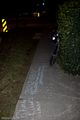
I made it a Tron (thanks Rhonda for reminding me) and intended to meet up with at least one of the other parties. I left home and ran pretty much straight there, realizing on the way that it would have been perfect for a Juggernaut instead of --heck as well as-- the Tron, and it may still qualify if I did the math. I zig-zagged across the road a few times because the sidewalk couldn't make up its mind what side to be on, and then realized I had gone half a block past it, thinking it was on the south side, not the north side of the Park. So I cut through the park and over the fence: had to have some effort involved in getting a Tron. I found the spot with a very careful non-path-cutting GPS dance, marked the dirt with xkcd and then stepped back to the sidewalk to chalk it, and there stopped the GPS/timer.
I spent an hour playing in the park across the street and running up and down the not-very-steep hill as prescribed in my triathlon training schedule. I meant to stay until Rhonda arrived, but the temperature was dropping fast as the sun went down and I was getting cold. So I went back to the coordinates, restarted the GPS, and ran home.
And yes, I remembered to stay west of my outbound path, very carefully not taking streets that might not go through and might force me east. I cut through a park and found a lighted artificial turf soccer field I didn't know was there. I thought that park had a running track. So the question is does it have both or did they take out the running track when I wasn't looking?
Sorry I missed everyone else. I hope you had a good time and were warmer than me. Also, I never saw the earlier party's geohash marker. There was some white stuff on the road that I thought was going to be a marker as I approached, but it just looked like pulp.
Robyn earned the Tron achievement
|
Wade
- Wade came home from work and said to Robyn, "Why are you here? I thought you would have gone geohashing by now."
- Robyn said she had been to the geohash, waited an hour, got cold and come home.
- Wade said it wasn't worth going if Robyn wasn't going to be there. It was pretty clear that everyone who was going to go had already gone, and there isn't much point in going there to turn around and go back home.
- Robyn was cold.
- Wade is angling for a new ribbon, awarded to those who live within twenty blocks of a street-access geohash and don't go anyway.
- It's 3C out there now, but we're expecting FOURTEEN tomorrow. Stunning!
Arbron
I had a meeting in the area at 12:30, so decided to stop by the hash after it was done. Unfortunately my meeting was moved downtown, but I wasn't going to give up that easy. Left Chinatown at 14:05, stopped for a quick Starbucks, and arrived at the hash point at precisely 14:30.
I walked down the block to the hash point and began taking a couple of photos. While doing so, I noticed a young woman across the street in the park making what appeared to be a sign of some sort. Curious, I walked across the street as she was finishing, and low and behold she had crafted some fine Geohashing signage. We talked briefly (turns out this was her first hash), took some photos, and said our goodbyes.
Then I went home and watched the iPad announcement :).
Rhonda
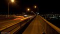
My plan had been to leave work at 17:00, get my bike from the parking downstairs, bike for Google's estimated 50 minutes, and be at the hashpoint about 18:00. At 16:57, a supplier that I'd been playing phone tag with all day called me. 25 minutes later, I was finally heading downstairs to get my bike. I was going to try for the Tron achievement, and thought innocently that going to the hashpoint via the Cambie bridge and returning via the Burrard bridge would work. (Robyn, you can stop laughing at me now.) Upon arrival at the Cambie bridge, I found out that the bike on-ramp was a spiral up. So much for Tron. I also realized along the way that I had forgotten to write down the co-ordinates in my late rush to get to my bike. Fortunately I remembered from Googling the route roughly where it was, and figured I could look up the exact co-ords when I got there if nobody else was around.
48 minutes after starting my GPS at work's garage door, I arrived at the hashpoint, to find somebody already standing there: robbat2. I parked my bike approximately where Google's aerial photography showed the hashpoint was. robbat2 had chalk, so we added our names and the time to the existing chalk mark in case anybody came by after we left, took some pictures, talked a bit, wondered if Robyn had been and gone already or was on her way, then eventually decided we were cold, and left at the same time.
At this point, it was dark, and I realized that because my bike's headlight had been stolen not long ago and I hadn't had a chance to get a new one yet, I would have to ride my bike home in the dark, without a headlight. I decided to take the prudent course of action, and while that did involve riding my bike in the dark without a headlight, it was only to the nearest skytrain station that I knew how to find (probably not the actual nearest one) and taking transit the rest of the way home.
I just realized: I never did program the co-ordinates into my GPS.
Wijnland
I went a little later than planned, left the house around 20.00 and Arrived at the location 12km and 43 minutes later in true TRON style with my own light trail behind the bike (made of a scarf and coat hanger). On my return I decided to avoid collision with any other possible tronners by taking the south route over richmond, Robyn we should compare our tracks to see if we made a valid TRON battle between the two of us. the one crossing in my trail is a nice split level one at the northside of the oak street bridge. Many had gone before me as could be seen from all marks on the location. did not see anybody in person, probably as the last visitor, but had a nice ride on my bike.
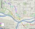
Tracklog for TRON archievement
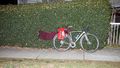
My Lightbike
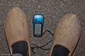
Coordinates Reached
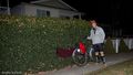
On location
Marks...
Lighttrails


Aarch, I withdraw my TRON archievement, too bad, I even dressed up my bike... After reading Rhonda's story and the rules found that Split level crossing is not allowed. I thought it was, otherwise a different route would have been just as easy (or even easier) for me. But I was too busy fighting imaginary (or mostly Robyn and Rhonda) battle enemies. Robyn an I did make a good battle I think, if we assume parallel passage in the 57 near the hash location. And I think I would have also cleared Rhonda, who was also coming in from the North. Maybe we can create a multiplayer TRON gratuitous ribbon that celebrates fighting a multiplayer battle, but allows split level crossing.
Wijnland and Robyn earned the MultiTRON
|


