2012-03-12 63 19

| Mon 12 Mar 2012 in 63,19: 63.2660062, 19.0786461 geohashing.info google osm bing/os kml crox |
Location
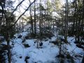
Location surveyed to be between a road and a lake, in another sliver of forest.
Participants
Plans
Seeing as I had access to a car, I would not waste the opportunity and scouted all the nearby graticules for possible points. Found a few and decided on two of them.
Expedition
So I set out in the car for the 100km-ish drive north. The day was quite windy and I could feel the winds grabbing hold of the car. When crossing the bridge, they had a warning for strong side winds, which I could really feel. The drive was otherwise rather uneventful up until past Örnsköldsvik. When passing the first landmark, the golf course in Puttom (a fitting location for a golf course), I knew it would be time to turn off the main road. After a series of progressively smaller roads, I reached the hashpoint. So I got out of the car, walked across the small logging grounds and stepped into the hashpoint area, which seemed to be prime lingonberry grounds. After marking the spot and doing some photos, I headed back to the car to drive to the next hashpoint: 2012-03-12 63 18
Tracklog
Device still in a not working well state.
Photos
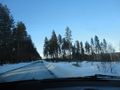
Arrival at the hashpoint.
Looking towards the hashpoint.
Map at the designated hashpoint tree.
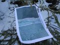
The hashpoint, with XKCD written in the snow!
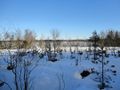
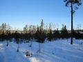
A view from the edge of the forest beyond the hashpoint.
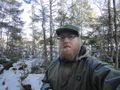
Me looking serious at the hashpoint.


Achievements
Penthok earned the Land geohash achievement
|
Penthok earned the No Batteries Geohash Achievement
|
Penthok earned the Graticule Unlocked Achievement
|
Penthok earned the Multihash Achievement
|