2012-05-20 47 -122
| Sun 20 May 2012 in 47,-122: 47.3144146, -122.2732569 geohashing.info google osm bing/os kml crox |
Location
In some stinging nettles near a road in west Auburn in a solar eclipse
Participants
Plans
Walk there from the Federal Way transit center. I could get there either noonish or evening, but not mid-afternoon. Will go for noon, for now hey wait, there's a partial solar eclipse that evening, peaking at 6:15pm. So I'll probably get there around 5:45 and try to experience a (cloudy) eclipse and a geohash simultaneously. Unless someone else prefers a different time.
Expedition
At a few minutes to 5 pm, I boarded the 577 bus downtown. It was overcast and drizzling, but hey, an 80% solar eclipse was about to start! About half an hour later, we arrived (a bit late) in Federal Way and with great anticipation I got out and began walking. The transit center was further north and west than I'd thought, with more intervening stoplights, so all in all I didn't reach the longitude of the hash until about 6pm. By this time, the eclipse was near peak and it was all dark and ominous. Of course, that could have just been the thick clouds and rain and the tree canopy that was covering the road. But it felt ominous, I tell you. Whatever.
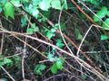
Anyhow, with bated breath I crossed the road to the south side (the hash side) and looked over the little guardrail and found not a pleasant friendly forest as I'd guessed from the satellite photo, but a huge overgrowth of nettles. I was wearing jeans and a raincoat this time, which was good, but there were a lot of em down there. No other large species as far as I could tell. The (amateur) ecologist in me was sad and the (um, amateur) geohasher in me was contemplating taking a Prize poultry again.
But it was less than twenty feet till I'd be within GPS error, and the thing was uncharacteristically jumping around, so for all I knew it would soon be even less than that. (Or even more, but I wasn't thinking.) This was too small a number for me to turn back. So I carefully made my way down the little roadside slope and began trying out various nettle clearing strategies. Progress was very slow at first, with the GPS coming out of the coat pocket every two feet or so (just in case, yknow), but eventually I realized that the nettle stalks snapped easily when stomped upon, and their remains stayed on the ground. Then things started to go a little faster, the GPS jumped favorably, and suddenly I was within error... 5ft! First eclipse geohash ever (at least judging from a google search for eclipse site:wiki.xkcd.com/geohashing/ and a perusal of the current events page... do let me know if you in fact have geohashed in an eclipse before!)
Relieved and excited, I swung my backpack around, freed it from the surrounding nettles, reached in for my camera... and pulled out my empty camera case. What?? Did I forget to put the thing away after uploading yesterday's pictures? Of course I forgot. Darn. But wait, I've been here before... yes, my dumbphone has a camera. And at least theoretically I can get the pictures off there and onto the internet. OK, cool. I took the necessary pictures (and a few unnecessary ones), bid the hashpoint farewell, and started back for the bus stop around 6:25. The eclipse had peaked at 6:15, probably while I was at the point.
First on-the-walk-back happening: I saw a "Welcome to Auburn" sign on a side road (photo below), which made me reconsider what city the hash had been in. (Later, internet at home quickly told me that Auburn has indeed annexed the hashpoint. Google maps doesn't know this yet, apparently.)
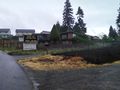
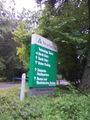
Second on-the-walk-back happening: I tried to go check out the Weyerhauser paper company's corporate headquarters. Why did I do something so crazy? Because on the walk there, I'd noticed signs pointing the way to its Bonsai Collection and Rhododendron Gardens, somewhere south of my route. However, I only had 15 minutes of slack for catching the last fast bus back to Seattle. And 7.5 minutes of strolling down Weyerhauser Way S. led me only to the sign pictured below, and no gardens or anything. I guess I'll have to return another time. (I did catch the bus, with about three minutes to spare.)
Post-expedition goodness
After dinner at home I determined to figure out how to upload pictures from my ancient phone thing, so that I could make today and 2012-02-20 47 -122 fully documented. Before, the main problem had been that it refused to do anything useful if it had no micro SD card loaded. But now I thought to check if my housemates still had such cards in their possession. Christof^ did not, but crazy enough, B Dawg^ did! On principle, though, B refused to lend it to me until I finally convinced him that the phone was so badly designed it couldn't copy from its native memory to my computer. A few minutes later, it was done. Now there will finally be photos for my forgotten-camera expeditions. Woo.
^Their actual names.
Photos
The hashpoint
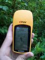
Proof!
Wake of snapped nettles leading to the hashpoint
Fun new word
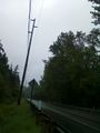
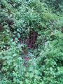
Road next to the hash. The eclipse would be visible in the sky over there if this weren't the Northwest
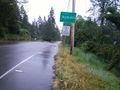
Real world 1, Google maps 0
I have no idea how much farther it was.


Achievements
OtherJack earned the Consecutive geohash achievement
|
(my first ever!)
OtherJack earned the Eclipse Geohash
|
(the first ever, period?)
OtherJack earned the Public transport geohash achievement
|