2012-06-24 52 1
| Sun 24 Jun 2012 in Norwich: 52.3918425, 1.4812542 geohashing.info google osm bing/os kml crox |
Contents
[hide]Location
In a pea field between Rumburgh Street and Stone Street, 7 km south of Bungay, Suffolk, UK.
Participants
Expedition
- Arrived. -- Sourcerer @52.3919,1.4815 20:36, 24 June 2012 (GMT+01:00)
It was one mile from the car's parking place to the hashpoint on a lane and down an overgrown field edge. This was a public footpath but it looked as though no one had used it this season. There was a lush tall growth of grass and wild geranium, thankfully with few thistles, nettles or brambles. There was wheat growing with fat green ears. The hashpoint was 12 metres into a field of peas grown for fodder. Neil got inside the circle of uncertainty but did not bother to get the reading down to zero as this would have caused undue crop damage. Three photos later it was another mile back to the car and home. There was bright setting sun and a few large rain drops fell.
Photos
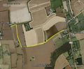
Google Earth Tracklog
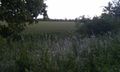
Wheat

GPS Evidence
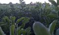
Peas


Expeditions and Plans
| 2012-06-24 | ||
|---|---|---|
| Newark, New Jersey | Zubenelgenubi | I overestimated my distance from the hashpoint after my first stop and had ... |
| Zürich, Switzerland | Calamus | The Altstetten district in Zurich. |
| Stuttgart, Germany | Ekorren | Münsingen, a piece of forest |
| Schweinfurt, Germany | Reinhard | On a paddock in Mönchshof near Römhild / Hildburghausen. |
| Frankfurt am Main, Germany | QuarterCacher, M | East of Limburg |
| Leipzig, Germany | Bazaruto | The "Hölle" near Taucha. |
| Norwich, United Kingdom | Sourcerer | In a pea field between Rumburgh Street and Stone Street, 7 km south of Bung... |
Sourcerer's Expedition Links
2012-06-22 52 1 - 2012-06-24 52 1 - 2012-07-05 52 1 - KML file download of Sourcerer's expeditions for use with Google Earth.