2012-07-14 52 0
| Sat 14 Jul 2012 in Cambridge: 52.9940494, 0.7526735 geohashing.info google osm bing/os kml crox |
Contents
[hide]Location
Sourcerer failed to reach the hashpoint about 1.3 km north of Scolt head Island.
Participants
Plans
Sourcerer (Neil) might try to get to this one. At low tide the sea might go out far enough. This will be at about 10:30 summer time in the morning and again in the evening. There is a good chance that the tide will not be low enough so some careful wading might be needed. Even this might not be enough but swimming would not be a good idea as there are cross currents that could sweep you into deep water. Also with the cool wet summer weather, the sea will be quite cold. There are few visitors to this bit of coast line so a rescue would be unlikely. The spring tides occur in about seven days time. On these days, the tidal ranges are much greater so there would be a better chance of success.
Expedition - Failed
- Neil's Droid: Expedition failed. -- Sourcerer @52.9821,.7511 09:35, 14 July 2012 (GMT+01:00)
This was one of the nicest failed expeditions to a most beautiful spot in eastern England. Scolt Head island is an inaccessible nature reserve. On this rather cool and breezy day, there were no other people in view. After walking for about 60 minutes along sea defence banks and dunes covered in wide variety of wild flowers, Neil reached the sea. Two shallow creeks had to be waded. It was cool enough for aching feet and shins more typical of April weather. The tide had not gone out as far as usual. A low pressure weather system and north winds were causing a tidal surge resulting in higher than normal water levels. Even in ideal conditions, the hashpoint would not have been reachable. Today the closest approach was 1.3 km.
During the summer, a ferry shuttles people to and from the island but only at high tide. At mid and low tides, it's possible to wade and walk one or two miles depending on the route taken.
Photos
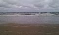
View North
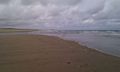
View West
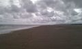
View East
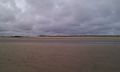
View South


Expeditions and Plans
| 2012-07-14 | ||
|---|---|---|
| Tecate, Mexico | LucasBrown | In the vicinity of Cedar Creek Falls, near the San Diego Country Estates (n... |
| Lawrence, Kansas | Someone went | In the woods near a residential area in southwest Topeka |
| Denver West, Colorado | Topbun | A few miles NE of Fraser, CO, in the Arapaho National Forest. |
| Bern, Switzerland | TheOneRing | near Zollbrück (canton Bern). |
| Basel, Switzerland | Someone went | In Freiburg. In a forest next to the A5 and the Opfinger See, where no musi... |
| Mannheim, Germany | QuarterCacher, M | (No, we're not going tomorrow morning ... was what he said when we departed... |
| Schweinfurt, Germany | Rincewind, Yakamoz | On a field near Bufleben near Gotha |
| Eindhoven, Netherlands | Eupeodes | On a golf course near Heelsum |
| Cambridge, United Kingdom | Sourcerer | Sourcerer failed to reach the hashpoint about 1.3 km north of Scolt head Is... |
| Oslo, Norway | Jonmarb | Next to a bus stop sign close to Maridalsvann |
Sourcerer's Expedition Links
2012-07-05 52 1 - 2012-07-14 52 0 - 2012-07-29 52 1 - KML file download of Sourcerer's expeditions for use with Google Earth.