2012-08-09 52 -0
| Thu 9 Aug 2012 in Northampton: 52.3125551, -0.6909587 geohashing.info google osm bing/os kml crox |
Contents
Location
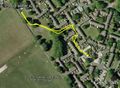
2) On an urban public path through attractive lawns and trees in Wellingborough, Northamptonshire, UK.
Participants
Expedition
- Arrived. -- Sourcerer @52.3125,-.6910 11:33, 09 August 2012 (GMT+01:00)
2 of 5 today :: 2012-08-09_52 0 :: 2012-08-09_52_-0 :: 2012-08-09_52_-1 :: 2012-08-09_53_-2 :: 2012-08-09_56_-2
Neil was geohashing on the way to a wedding in Scotland. This was attempt two of five. To reach this hashpoint, a ten mile detour was needed to get to Wellingborough. The hashpoint was on a public path through an attractive urban corridor with lawns and mature trees. It was easy to find a parking place and the walk was short. Wellingborough looks like an attractive place to live.
Photos
Google Earth Overview
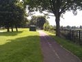
The Terrain
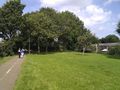
The Terrain


Expeditions and Plans
| 2012-08-09 | ||
|---|---|---|
| Atlanta, Georgia | NWoodruff | In a well over grown lot in Vinings. |
| Youngstown, Ohio | User:Fezzic181 | Found the spot out in the middle of the state game lands. |
| Billings, Montana | Rory | Lake Elmo State Park north of Billings, MT. The actual hash point is in th... |
| Northampton, United Kingdom | Sourcerer | 2) On an urban public path through attractive lawns and trees in Wellingbor... |
| Birmingham, United Kingdom | Sourcerer | 3) A few metres off a public footpath in a hay field. This was near the Gra... |
| Cambridge, United Kingdom | Sourcerer | 1) Sourcerer failed to reach the hashpoint in a very muddy pig field. |
| Amsterdam, Netherlands | Marvyn | Behind a container-like building in some shrubs in an urban area in Hoofddo... |
| Manchester, United Kingdom | Sourcerer | 4) Close to junction 12 on the M56. The hashpoint was on or very close to t... |
| Dundee, United Kingdom | Sourcerer | 5) Beside the coast road east of St. Andrews, Fife, Scotland, UK. |
Sourcerer's Expedition Links
2012-08-09 52 0 - 2012-08-09 52 -0 - 2012-08-09 52 -1 - KML file download of Sourcerer's expeditions for use with Google Earth.