2012-08-16 47 -122
| Thu 16 Aug 2012 in Seattle: 47.6656215, -122.3255988 geohashing.info google osm bing/os kml crox |
Location
Seattle, the middle of Latona Avenue NE, just south of 51st NE.
Participants
Expedition: Thom
Got out the door to work at 6:20, made it just across the freeway at 6:30. Time to punch up the Geohash Droid and see where the spot is.
Well, it was south of my normal route to work, but zooming in, it looks to be right on the road. Hot diggity - let's go!
Unfortunately, I cleaned out my car yesterday to go to the dump, and didn't restore my sidewalk chalk to it's rightful location. So I was unable to mark the spot for any future geohashers.
And speaking of them, this particular intersection will be traveled by thousands of people today, as every weekday.
Anyhow, shortening the long story, I reached the spot quite easily and snapped a few photos (below). The picture of geohash droid is blurry - I really need to get better at shooting it. I then walked up and down the neighborhood to see if any young'uns had left their sidewalk chalk for me to borrow, but alas there was none.
In the immortal words of the former governor of California, "I'll be back"
Plans
Open for a second visit and meetup, sometime after 4:30 --Thomcat 10:45, 16 August 2012 (EDT)
- This is really close to where I work, so can make it over at any time... post when you've got a better idea! -- OtherJack 12:48, 16 August 2012 (EDT)
- Won't be home till about 6 again but this is just a quick jaunt over near I5 so soonest I could be out there is probably 6:30 -- p4r4digm 14:09, 16 August 2012 (EDT)
- P4r4digm, can you make it *any* earlier than 6:30? I have to be at a meeting before 7pm which is roughly 20 minutes away; meeting on the spot at 6:20 will work for me. Can you stop earlier on the way home? --Thomcat 14:39, 16 August 2012 (EDT)
- Ah, good call, I'll just head there straight from work. I work downtown so I can nab a bus that drops me off on I5 and 45th and hike over there. Best case is getting there a little before 6 and I'll just hang till people arrive. -- P4r4digm 14:45, 16 August 2012 (EDT)
- A little before 6 - I'll be there, with chalk and a camera. --Thomcat 16:06, 16 August 2012 (EDT)
- Awesome, I'll plan on getting there by bike at about five minutes to 6. I'll probably only stay a couple minutes because of other plans that came up. I'm also pretty sure this is the most colons I've ever typed on one of these... -- OtherJack 16:50, 16 August 2012 (EDT)
- LOL --Thomcat 09:47, 17 August 2012 (EDT)
- Awesome, I'll plan on getting there by bike at about five minutes to 6. I'll probably only stay a couple minutes because of other plans that came up. I'm also pretty sure this is the most colons I've ever typed on one of these... -- OtherJack 16:50, 16 August 2012 (EDT)
- A little before 6 - I'll be there, with chalk and a camera. --Thomcat 16:06, 16 August 2012 (EDT)
- Ah, good call, I'll just head there straight from work. I work downtown so I can nab a bus that drops me off on I5 and 45th and hike over there. Best case is getting there a little before 6 and I'll just hang till people arrive. -- P4r4digm 14:45, 16 August 2012 (EDT)
- P4r4digm, can you make it *any* earlier than 6:30? I have to be at a meeting before 7pm which is roughly 20 minutes away; meeting on the spot at 6:20 will work for me. Can you stop earlier on the way home? --Thomcat 14:39, 16 August 2012 (EDT)
- Won't be home till about 6 again but this is just a quick jaunt over near I5 so soonest I could be out there is probably 6:30 -- p4r4digm 14:09, 16 August 2012 (EDT)
Expedition: p4r4digm
I work downtown so bussing and walking was a pretty straightforward way to reach this one. UNfortunately, I hadn't checked the hash until after I left my apartment wearing flipflops. This proved to be a terrible decision as 10 or so blocks of walking later my feet are still sore.
But this was my first successful geohash! And I got to meet what seems to be the current active Seattle hashing community!
Check out my Instamapper Tracklog here.
Expedition: OtherJack
I showed up a bit early but found that p4r4digm was already there, though I had to convince him to locate the point with his phone gps since I'd forgotten mine... it turned out to be in/near a bush by the side of the road, which was nicer than in the road itself. After I satisfied my standards by physically passing through the point, we talked until Thom and his young daughter showed up, and she expertly took our picture (which Thom will probably upload.) I left right after that to join an impromptu sailing expedition (of all things), which is why I couldn't/didn't go for the Tron ribbon.
I actually have an xkcd-reading friend who lives about 50 yards from there, like he could throw a stone out the window of his house to the hashpoint, and he told me earlier he might be around!... but it sounds like it didn't work out. Oh well.
Expedition: StanD
I noted that the geohash was only 2 and a half miles from home so I resolved to get there despite a busy day at work. I didn't get out until 6:00pm and I figured since it was so close I'd just run there. I used my Garmin watch to track myself and I took a photo with my phone camera of the sign that someone has posted at the intersection. (Note how I accidentally got the street sign in that photo). I wonder if that Garmin connect page constitutes proof for the Walk geohash achievement?
Photos
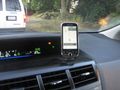
Geohash droid says we are there
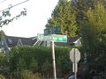
A quick snap of the intersection
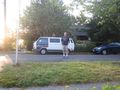
Timer, standing on the spot
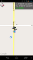
p4r4digm checking in with proof
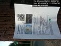
Thanks for the sign! @47.6657,-122.3254
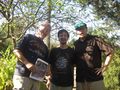
First group shot at the hash
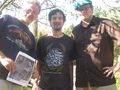
This is our album cover


Achievements
p4r4digm earned the Land geohash achievement
|
p4r4digm earned the Public transport geohash achievement
|
p4r4digm earned the Meet-up achievement
|
OtherJack and Thomcat earned the Meet-up achievement
|
OtherJack earned the Bicycle geohash achievement
|