2012-09-07 48 8
| Fri 7 Sep 2012 in 48,8: 48.2626457, 8.3186415 geohashing.info google osm bing/os kml crox |
Location
Just anywhere in a peace of forest not far away from an easy to reach street, in an area i know. I thought...
Participants
Plans
I just take my bicycle, my cellphone, a (working) camera and of course the GPS-device with me, make a nice tour and be back in two hours. This time with good proof.
Expedition
At first everything was easy, it goes down a long way and very steep back up, from about 384m altitude to 768m in about 6 kilometers, but i like to ride with my bicycle so i made it without problems. On the way up I thought about getting the Tron achievement. What I regretted just about a kilometer later when i accidentally took a path which had an dead end covered with nettles. But because I am an idiot (and because i thought about the MNIMB achievement) I have taken my bike onto my shoulders and made my way through the nettles and the forest until I found the next street or path crossing my way (I have proof of this on my cellphone, but at the moment no way to connect it to the PC, I will upload them as quick as possible). Luckily i found something like a path halfway through this forest and after about 50 meters crow i was back on a tarred street. On my way through this peace of forest i found a broken wine bottle and i took it with me, but because I had nothing to carry it further with me I put it back down on the side of the street.
After this I moved easily on, the street seeming to point perfectly into the right direction and I came into 700 meters near the Hashpoint. There i had to leave the tarred street again, but I saw another man on a bicycle coming out of the forest, showing me (indirectly) where my track will go on. Without intention I moved onto a private area, because I took the way directly between two houses of one farm and not the way around. The farmer pointed it out to me and I apologized but asked if I could move on. I think he just said it because he didn't want it to happen again and not because of anger.
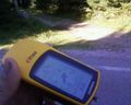
I rode on a way which didn't seem to have a dead end, but... it has, again. Again i picked up my bike and walked. It wasn't far to the ridge of the hill where in our area always is at least a small path. I found a path but it was really small and obviously out of use. But I reached another way and now i was only about 50 meters crow away from the Hashpoint. But it was down a very steep side of the hill, so i decided to ride down and try it from the other side and as I hoped their was a way which came about 30 meters into reach to the Hashpoint. I layed my bike down near the way and made the rest by feet. I reached it! Everywhere was undergrowth, except at the Hashpoint (when I could say hat with a accuracy of about 10 meters), and funnily i found tracks of boars.
Attentive to not cross my own path I walked back to my bike which i wisely thrown a bit away from my old path. Then walked down the way but again on the right side and then a small shortcut down to the street. Their I remembered I forgot to make a stupid grin photo which I took there.
This part of the journey I made in about One and a half hour so I thought I have much time for my way back home and because I am young and stupid I wanted to get back to my previous Geohash to take proof. I thought about a photo of the Red Stone I have described in my first expedition. This point lay almost on the way I thought of back home and I didn't had to cross my own path.
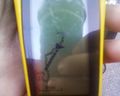
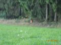
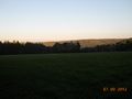
But it wasn't as easy as I thought, I became hungry because I did not take anything to eat with me, and i became hungry because I drunk everything of my water. Stupidly I didn't even had money with me. So my average speed decreased from about 20 km per hour to 14 which is a heavy change. But I made it back to the Hashpoint of the previous day. Almost! I came into sight but a silent hiss from out of the forest frightened me for a short second. In the forest on a hunter-hiding-place (don't know the word for it) sat a female Hunter aksing me politely to move on silently. I took two photos quickly, one of the view (almost) from the Hashpoint and one of the Hashpoint itself with an exaggerated Zoom, it isn't really proof, but it was to much work to get there too to make no photo.
After this I made my way back home but the sun already gets down and it became very cold in a short time, especially if you ride down a street with about 35km per hour and only short clothing. I reached a city I knew the way which I had to take to don't cross my path was about 40 minutes until I will be home, even the Short way was about 30 minutes (Both about 200m altidude to drive upwards, which I knew already because I worked their for about 3 years, once a week). And this if I where in normal or good mood, not like this evening already frowning and hungry. So I gave up and called my parents which luckily already closed the shop but did not already drunk anything. About 15 minutes later I was sitting in the warm car.
My Parents had a happy time when I asked them to drive the slightly longer way home, because of the game I play.
As Summary: I've ridden more than 50 kilometers on my bike, walked quite a bit and at least almost 20 kilometers with the car. I needed almost 5 hours for it.
Tracklog
Like the previous day, I've lend The GPS device. Without a way to connect it to the PC. I tried to make proof with my camera, poor but the only thing I could have done.
I tried to reconstruct my journey with the following maps as best as i could (I have to use more because of sometimes i used the street like a car and sometimes I was like a walking Person...)
http://goo.gl/maps/w7jfk From A to B I have had to go through the nettles, I used the Juggernauts way (someone correct it if he understand what I mean and could say it better). From C to D I made the mistake i mentioned below to cross private property. The way facing north is nonexistent as i could say, but from E to F is one halfway through. Then I took the street from F to G. From G you could see a way towards the Hashpoint, this one I used. Then I got back down a bit on it (attentive to not cross my way!)
http://goo.gl/maps/UU4Nn This Section isn't exact, but you see clarly: I did not have to cross my own path. The C is placed where I took the photo of 2012-07-06 Geohash
http://goo.gl/maps/1oxDf My way back home, i made with my parents.
(I'm not really from Triberg, but my home is exactly on the way.)
Photos
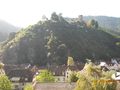
The Castle of Hornberg, quite a nice view
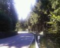
It was really steep sometimes
On the green sign you could see the altitude: 786m
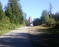
The last point before its going to be tricky
I thought I have made most of the way...
The nettles, after I'm through
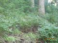
Proof I reached the Hashpoint
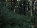
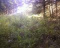
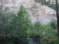
Impression of the surrounding forest
Boar tracks at the Hashpoint (what a crappy picture)
It is not as it look on the first glance!
I heard about the Stupid Grintm...
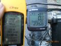
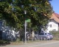
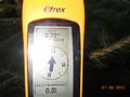
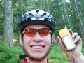
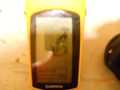
Trying to compare GPS device and speedometer
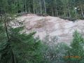
A quarry i found on my way back,...
...it seems to be unused this days.
Picture of the Red Stone on the white tree stump
and again with an exaggerated Zoom level
The View we had at my first Geohash
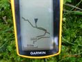
Back at home trying to picture the tracklog, I know it's bad.


Achievements
RecentlyChanged earned the Bicycle geohash achievement
|
RecentlyChanged earned the Tron achievement
|
RecentlyChanged earned the One with Nature Geohash Achievement
|
RecentlyChanged earned the Consecutive geohash achievement
|
RecentlyChanged earned the Two to the N achievement
|