2012-09-07 52 0

| Fri 7 Sep 2012 in Cambridge, UK: 52.2626457, 0.3186415 geohashing.info google osm bing/os kml crox |
Contents
[hide]Location
In a field just outside Burwell, northeast of Cambridge. The B1102 runs past the field, with a carpark (intended for walkers) about 300 metres to the southwest, so this is decidedly accessible.
Participants
Expedition
Having made no plans to speak of, apart from "going at some point during the day", I ended up doing various other things that needed to be done, and only thought about actually going to this hash at about 8pm. Accordingly, I finally left the house at 10:13pm, drove to the vicinity of the hashpoint where I parked the car in a handy small carpark intended for walkers tackling the nearby Devil's Dyke Path, crossed the road and walked first along the edge of the field, and then across the field itself. There had been crops at some point, but they had been harvested and all that remained was about 10 or 15 cm of stubble.
The hashpoint was easily located although the GPS stubbornly refused to show me any distance nearer than a metre until I walked away and came back again. The futility of trying to take good photos in the dark was re-examined, and I watched the stars for a bit, as there were a lot more of them visible from here than from Cambridge city, where I live. The moon was just rising, too, and was huge and orange. After that I made my way back the way I'd come, and arrived home not quite an hour after I'd left.
Ordinarily I might well have cycled to this hashpoint, but as it was, this was a fun way to end a busy day, so no failure there.
Photographic documentation
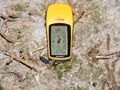
The usual proof of hash
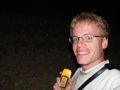
Happy hasher, in the dark and slightly stunned by the flash

Shiny ribbons earned
Benjw earned the Land geohash achievement
|