2012-10-13 49 9
| Sat 13 Oct 2012 in Würzburg: 49.6545215, 9.9964695 geohashing.info google osm bing/os kml crox |
Location
Today's location is in an empty field near Giebelstadt.
Country: Germany; state: Bayern (Bavaria, EU:DE:BY); administrative region: Unterfranken; district: Würzburg rural district
Weather: lightly clouded, around 13 °C
Expedition
Danatar
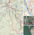
A sunny Saturday without work? It's a rare opportunity, and I was not going to miss it. When Google Maps proposed a different route than the one I had first thought of, I decided to use both and earn myself another Tron achievement. I knew that the road between Heidingsfeld and Fuchsstadt would be a long slope on a country road with many cars, so that part would have to be on my way back, downhill. I started at 14:40 and kept away from the Main river, using the small streets of the Sanderau district. Only later did I use the cycling track along the Main to go past Randersacker to Sommerhausen. There I found the first challenge of the Tron requirements. To get on the bridge across the river I first had to get from the cycling track to the car road. But since there was a guardrail I had to continue on the cycling track until I was past the first ramp. On the other side, I was able to carry my bike up the slope to the road. Continuing counterclockwise would lead me up to the bridge, but then I would have crossed my path. Instead I crossed the road, smiled to the police car that came from the other direction, cycled a short distance towards Sommerhausen and from there took the ramp that was leading up to the bridge from the other side. On the other side of the bridge I used the main road for a bit, then a small track along the Main to Goßmannsdorf. There I left the Main and cycled up a slope, first on a country road, then on a tarmac track, then on a steep gravel track, then... oh no, why is there suddenly only a grass track? That's the reason I have a mountain bike instead of a racing bike. Cycling was difficult and slow, and it was almost 4 pm now. Finally I found another tarmac track and reached the edge of the hashfield at 16:05.
The field was empty. Certainly harrowed, perhaps planted, but there were no little plants visible. Probably winter wheat (>90% of German wheat), which is planted in autumn and only starts growing in spring. I took my bike and walked across the field towards the hashpoint, making a curve in the end and reaching the spot from the southwest. Since GPS reception on open fields is excellent, I didn't have to do a GPS dance before reaching the spot. I took pictures and continued northeast, back towards the track. Then I cycled north.
In that area I didn't know which track to take because there were too many and I didn't have a map printout (while writing this I remember there might have been a low-res map in my cycling bag...). So I was zig-zagging west and north, along other grass tracks, until I reached the main road. On that road I found a do-it-yourself pumpkin selling station with 4 heaps of differently sized and priced pumpkins for 1, 2, 3 and 4-7 Euros. I only had a 5 € bill so I took one of the smaller pumpkins from the 4-7 € heap. Then I took the next tarmac track towards the north, where I knew Fuchsstadt to be. Soon this track also turned to grass, but after a while I found the correct track (well, at least the one parallel to the one I had planned). Soon I was at Fuchsstadt and could roll downhill for a few kilometres. In Würzburg, I was very tired and getting slower, also a bit sick from the chocolate bars from my bike bag which turned out to be 1.5 years beyond their date of expiry, but finally I arrived at home.
This is my 20th Saturday Meetup. In total, I cycled 42.5 km, all on a tron route.
Danatar earned the xkcd Viginturion achievement
|
Danatar earned the Tron achievement
|


