2012-11-04 29 -82
| Sun 4 Nov 2012 in Gainesville: 29.8422319, -82.7904151 |
Location
A stand of trees on a pasture in the middle of a bunch of private property. But that is okay because...I'm flying over it!!
Participants
Plans
The original plan on Sunday was to fly over the hash points for Friday, Saturday, and Sunday for the Gainesville, FL graticule. Then for the Sunday (current day) location I'd climb to 5500' or so and get the Mile High achievement.
Expedition
Heavy fog covered North Central Florida both Saturday and Sunday morning. I got the airport about 9:45am for my 10:00-13:00 rental reservation and the airport was under full IMC conditions. Not being instrument rated there was nothing I could do but complete my pre-flight and wait on the tarmac for the fog to lift.
Gainesville isn't a particularly busy airport but on a Sunday after a home Gator football game there is a steady stream of executive aircraft leaving the airport. And I'm the sort that can sit and watch airplanes all day.
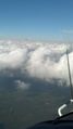
Finally the fog burned off and I was able to takeoff to the southwest in search of Friday's location. Less than 10 miles from the airport, however, was an almost solid band of cloud cover extending north-to-south and all the way west to the Gulf Coast. Worse, the bottoms of the clouds were at about 1000' AGL, meaning they were too low for me to scoot along underneath. All three hash points were going to be under cloud cover.
I decided to abandon, for now, the previous day's hash quest and go striaght for Sunday's. The chances of me seeing the ground at the point were pretty slim and I was uncomfortably nervous that when I returned to Gainesville the cloud bank would have moved east, preventing me from landing. The gaps in the cloud cover were nowhere large enough for me to drop down between clouds and maintain minimum VFR clearance.
So now I was left to trying to fly over the unseen point using only the GeoHash for Droid on my phone. It would be helpful if the dot representing the current location on the app had an arrow showing direction of travel...but the helpfulness is probably somewhat unique to this attempt given that I'm approaching the invisible point without landmarks at about 90 knots.
When I fly I usually track my flight with an AMOD gps logger. I would use that later as my 'proof' of how close I got. The two aerial images show my flight path extruded to the ground by a wall with the hash point located between the two passes I made at the point.
I was flying at 4500' and on my second pass my ground track got within 280' of the point. If my understanding of arc-seconds is correct I'm about 3 arc-seconds from the point. Well within the 10 arc-second accuracy requirement.
I made it.
Alas my concern about cloud cover over the airport had increased the pucker-factor to the point where it was time to head straight back so I abandoned the mile high achievement.
For now.
Photos
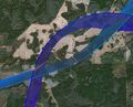
Ground/flight path
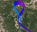
Ground/flight path, oblique

Somewhere down there
Somewhere down there


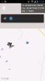
Screenshot

The Droid requires a cumbersome two button press to capture a screenshot. I had to hit the power button and the down volume button at the same time. This screen shot was just over a mile away. I took another one when I was closer but because I hit the power button first and I got a nice screenshot of the power-down confirmation screen. Note on this picture I must have hit the volume button first as it has been turned all the way down. Technology -vs- fumble-thumbs. Can't win. Maybe I should have practiced more.
Achievements
Grumpa earned the Air geohash achievement
|