2012-12-16 55 13
| Sun 16 Dec 2012 in 55,13: 55.8960573, 13.3837762 geohashing.info google osm bing/os kml crox |
Location
Participants
Plans
Close to home, perhaps i a reachable area. Try to get get there.
Expedition
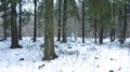
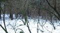
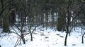
When I arrived near Stehag I realized that it was not in the forest I believed it would be, but in another unknown part of Stehag. I parked the car as close as possible to the geohash location (a nice parking area) and started to take the walkt to what I believed to be the nearest point. Unluckily I found the passage nearer the geohash to be impossible to jump over, a rather deep stream with a barbed fence stopped me. I thought of different ways to cross the stream but had to turn back the 650 meters to get closer to my starting point. Back there I did see some tracks in the nearest grass which made me take another route back through the forest. Id seemed like some dog owners must have been taken this route before because there as a small track inside the forest which I traced with my GPS, which would later be added to OpenStreetMap. I followed the track and found a older part of the forest which had been transferred to a something like a eco-forest trust. The forest had a sign which meant it would not be changed or harvested the next 50 years. The owner would get some small money from the government to keep it forest as it had always been for the next 50 years. It was the first time I did see such a sign, even if I had heard about it from the radio. I got nearer the geohash but took a route along the track the get the full trace before visiting the geohash. The geohash was close to the track, and some photos was taken before I tried to make the full route for OpenStreetMap. After all I had walked about 3,2 kilometers before returning to the car and took off home.
Photos

Proof
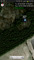
Map

The grin
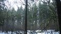
North
East
South
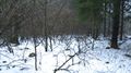
West
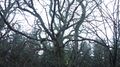
Old trees
Old trees
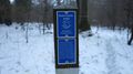
Sign


Achievements
Llavids earned the Land geohash achievement
|
Llavids earned the OpenStreetMap achievement
|
Other Geohashing Expeditions and Plans on This Day
Expeditions and Plans
| 2012-12-16 | ||
|---|---|---|
| Carrabelle, Florida | Geoff, Erica | Off Alligator Drive. Take I-10 west, head to the Valdosta graticule first, ... |
| Atlanta, Georgia | NWoodruff | On the edge of the street in Sandy Springs. |
| Zürich, Switzerland | Someone went | Forest o.O, crazy thing!! |
| Pforzheim, Germany | Someone went | Forest |
| Norwich, United Kingdom | Sourcerer | A small photovoltaic farm at Trimingham very close to the north east Norfol... |
| Malmö, Sweden | Llavids | Stehag, Eslöv, Skåne, Sweden. |