2012-12-22 41 -87
| Sat 22 Dec 2012 in Chicago: 41.6976274, -87.9700279 geohashing.info google osm bing/os kml crox |
Location
Just off the trail of a forest preserve in Darien.
Planning
- I'm planning on heading there, timing unconfirmed but hopefully around 4 PM. Able to adapt if anybody's interested in meeting up at another time. -Haberdasher 12:28, 21 December 2012 (EST)
Participants
Expedition
This expedition was... frustrating.
Getting to the forest reserve wasn't too difficult. My mother decided as we got there that it "wasn't safe" for me to go to the hashpoint alone, even with my dog with me, so she came with, which slowed us down. We kept encountering detour signs for the main trail, which I had planned on using, and made me worried that the hashpoint was currently off-limits, which turned out not to be the case. When we were about halfway there, she started saying that it was too far, that I'd never make it back before dark (the park closes an hour after sunset), and that we'd better turn around. After some negotiation, I went onwards with the dog while my mother waited on a bench.
Balancing the GPS, camera, and leash was difficult. Balancing all three along with my cell phone when my mother repeatedly called to confirm that I was still alive was more difficult still. When we were about 500 feet from the hashpoint, the dog suddenly decided that she wanted to head back, and I had to practically drag her over... at which point I realized that carrying a dog on a leash through the brambles would be a difficult task indeed. I headed back, defeated.
Upon arriving back where my mother was, she sensed my frustration and said that I should go on without the dog, even though it was almost dark. Even though I was willing to call it a day, she insisted, so I headed back. I quickly realized that when adjacent to the hashpoint I had confused north and south (I've never had a good sense of direction...) and that the brambles that faced me were thus not the ones I had attempted to enter earlier. Upon arriving again in the area, I found that the actual area of the hashpoint was mostly tall dead grass rather than trees and brambly branches, which made reaching the hashpoint easier. However, it was here that my GPS refused to update its location, as it has a habit of doing... and while waiting for it to update, my mother called, panicked that I wouldn't make it back in time. In the hurry to get out before the park closed, I completely neglected to take a photo of my Stupid Grin.
Once safely in the car again, I hoped that the car thermometer, the only one I had access to, would at least declare this a Frozen Geohash... but no, it said that it was 37F, still definitely above freezing. Although several minutes later it read 31F, and I doubt the temperature had changed that drastically... still, whatever the actuality of the temperature at the hashpoint, my proof regarding it being possibly below-freezing is lacking. There was also nowhere near enough snow remaining on the ground to make a snowman, even if I'd had the time.
(Edit: Weather.com says that the high for December 22nd in Darien was 31F, below freezing. I'm tentatively trusting weather.com on this one and calling it a Frozen Geohash after all.)
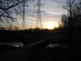
The forest preserve was pretty, though, especially around sunset. I also learned some about the area- apparently the Waterfall Glen County Forest Preserve, the one containing the hashpoint, encircles Argonne National Laboratory. And it was nice to get outside and get some exercise with the dog, even if the conditions were less than optimal.
VERY BELATED EDIT: I noticed just today (2013-12-16) that this hash was both in the Chicago graticule and in DuPage County. Given that DuPage County only spans the Chicago and Aurora graticules and that I have visited several DuPage Aurora graticule hashes, this means that I have achieved the Regional geohashing achievement for the region of DuPage County! Nice to discover, even a year after the fact.
Pictures
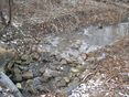
Little stream
Big stream
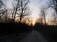
Trail
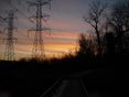
Big stream again
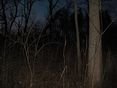
Hashpoint
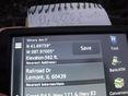
GPS
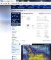
Below Freezing


Achievements
Haberdasher earned the Regional geohashing achievement
|
Haberdasher earned the Frozen Geohash Achievement
|
Haberdasher earned the Sunset Geohash Achievement
|