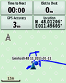
2013-01-11 48 11
| Fri 11 Jan 2013 in 48,11: 48.0120581, 11.4960484 geohashing.info google osm bing/os kml crox |
Location
In a forest just S of München, near the suburb of Grünwald.
Participants
DerFlob and The_T-Man, Zertrin, and vermouthandgin !
Plans
We're (T-Man, Scherzkeks, Flob) planning to go to Grünwald by Tram and walk from there. Seems like Zertrin will go by car. Official expedition start will be adjusted with respect to everyone taking part. At the moment it looks like the meetup will occur shortly past 5 p.m.
- DerFlob, Scherzkeks and The_T-Man are aiming for 2013-01-11 48 11. Everybody's invited to join!
- At what time are you planning to reach the hash? I have excursion with the uni at the beginning of the afternoon (14h) and I don't really now when it'll finish (I think it'll last at least 2 hours). I may try it right after, by car probably, but i still need 1 hour more to go. In any case probably not before 17h but I really don't know how much time the visit will last so maybe sooner (or later). In any case we'll try this hash too. — Zertrin 17:37, 10 January 2013 (EST)
- With the current schedule, it looks like we should arrive somewhat between 16:10 and 16:30 at the location. From what I know our deadline lies somewhere around 6-7 p.m., so shifting the whole thing back would pose no problem. Getting there in the dark could be a bit trickier than with daylight, but this is about challenges anyway, right? :P Just feel free to contact me for schedule changes at short notice (+49xxxxxxxxxx). -The T-Man 18:28, 10 January 2013 (EST)
- will do ;) I removed your number after taking it to prevent it to be indexed on the web. — Zertrin 03:35, 11 January 2013 (EST)
- With the current schedule, it looks like we should arrive somewhat between 16:10 and 16:30 at the location. From what I know our deadline lies somewhere around 6-7 p.m., so shifting the whole thing back would pose no problem. Getting there in the dark could be a bit trickier than with daylight, but this is about challenges anyway, right? :P Just feel free to contact me for schedule changes at short notice (+49xxxxxxxxxx). -The T-Man 18:28, 10 January 2013 (EST)
Expedition
DerFlob and The T-Man
DerFlob and The T-Man met up at shortly past 3 p.m. at Silberhornstraße, an urban subway stop where the tram to Grünwald would depart. Unfortunately, Scherzkeks was unable to attain. The route to the hashpoint was extremely similar to that of Geohashing Day of 2010 - the difference between the two being just 1.24 km. This point was farther away, so it didn't qualify for a Déjà vu geohash achievement. We decided to take the curvy path through the forest again, which turned out to be quite a bit longer, and full of obstacles (puddles, fallen trees, slippery branches and roots), but very beautiful nonetheless. As we approached the hashpoint, the terrain tended to become more hostile and daylight began to fade. We reached the hashpoint at around 5 p.m. At the spot, a note was prepared for expeditioners to come, The_T-Man ridiculed himself as he attempted to stick it onto a branch at about 2,6 m above the ground and almost tore it apart. In the end, it was set up as imagined and we walked back towards Grünwald (this time on the straight, shorter and more convenient path), stopping there at the butcher's to get something for dinner and taking the tram back home.
Zertrin and vermouthandgin
This afternoon I had a planned visit of a power plant north of Munich (part of a lecture I'm following this semester at the university), which was due to begin at 2 p.m. but I didn't know how long it would take.
In the meanwhile I had seen that DerFlob, Scherzkeks and The T-Man were planning to reach the hashpoint after some months of inactivity for our graticule. I had spotted the hashpoint to be not too far and possibly reachable, but because of the planned visit aforementioned, I would probably not have tried to reach it if I didn't knew that my fellows geohashers in the graticule were planning to do it.
After having explained that it wouldn't be possible for me to reach it before 5 p.m. in the best case, and more probably not before 6 p.m. (which also meant that it would be a night expedition in the forest), I finally called The T-Man at 5:15 p.m. to tell him I just got out of the visit, and that I still needed at least one hour to pick up my girlfriend (for her first geohash!) and then drive to the hash. They were already near the hash and so we decided not to try to meet-up together as it would have been for them too long a waiting in the cold (frozen geohash incoming ^^).
Thus, without the meet-up constraint, I took time to drive home (took time too to stop at a police control (papers, alcohol...)), pick-up my girlfriend (whose nickname here will be vermouthandgin), and go to the supermarket before attempting the hash so as to have something to eat when we'll be back.
Then comes the expedition actually:
First goal was to reach a hamlet called Frundsbergerhöhe by car and park there, close to the hashpoint (around 400 meters). The drive was almost uneventful, apart from some direction mistakes, as I tried to use the Route planner and Navigation of the eTrex, which always told me to turn left or right just when i was already in the middle of the intersection or just after it ><' or proposing me to take forest paths (without surfacing). I fell back on reading the map myself and finally we found the hamlet and parked there.
It was already full night at that time (7:10 p.m.) and the forest was very dark without moon in the sky. It was pretty cold too. We tried to find some path that appeared on google maps, but like a previous expedition, the definition of "path" according to google is to be taken very cautiously as the paths were merely directions where the trees had been cut, but still full of dead leaves and wood...
The tricky part of the expedition came to us quickly, as the terrain was very very uneven, with many big differences in altitude to cross (sometimes close to 130 % of slope gradient!). The T-Man tried to warn me about that when I had him on the phone, but I didn't expect such difficulty. Additionally the soil was humid and was beginning to freeze, plenty of dead leaves and, to top it all, totally dark. Fortunately I had brought two headlamps for each of us, and we helped ourselves with wood-sticks found on place.
After having overcome many down- and uphills, which I didn't know if we would be able to cross again on the way back due to the big slope gradients, we got close of the hash, and when we were about 10 meters away of it we saw the marker left by DerFlob and The T-Man near the hashpoint, which helped a lot for the final meters.
Finally we had reached it, around 7:53 p.m. !
We took some pictures, among them a drawn by light XKCD and the thermometer I brought with to prove the Frozen Geohash achievement.
Then we went back, basically following the same path as before, with some enhancements to circumvent the trickiest parts we met on the way to the hash. We took the car again and headed home, the drive back being uneventful.
Tracklog
Photos
DerFlob and The_T-Man
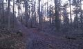
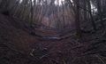
The muddy path through the Forest
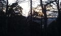
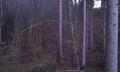
Forest impressions
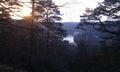
This view, this time a bit more picturesque
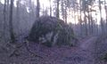
The stone The_T-Man dubbed "Bob Ross Rock" two and a half years earlier
All those obstacles! They always look so puny on the pictures - but they were ferocious!
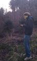
DerFlob at the hashpoint
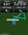
Wouldn't go below 1 metre
Zertrin and vermouthandgin climbed down there hours later
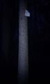
Our note


Zertrin and vermouthandgin
Hashpoint reached!
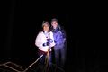
Zertrin and vermouthandgin at hashpoint

Light XKCD by Zertrin and vermouthandgin at hashpoint

Frozen Geohash!!!


Achievements
Zertrin and vermouthandgin
Zertrin and vermouthandgin earned the Frozen Geohash Achievement
|
Zertrin earned the Drag-along achievement
|
Potentially:
Zertrin earned the Police Geohash Achievement
|
DerFlob
DerFlob earned the OpenStreetMap achievement
|