2013-01-12 -37 145

| Sat 12 Jan 2013 in -37,145: -37.3984046, 145.9858954 geohashing.info google osm bing/os kml crox |
Location
In scrub off a 4wd track, 10km from the Eildon-Jamieson Rd, in Big River State Forest.
Participants
Plans
A short distance into a 200km training ride, I discovered the existence of the hash. I've seen so many of these hashes around Eildon, that are completely inaccessible - a very long drive along a windy road, then probably dozens of kilometres of dirt road, and probably more kilometres of bush bashing. It's steep, sometimes mountainous terrain. So, this one looked kind of...doable. My route for the day already involved the whole Jamieson-Eildon Road, so, why not? (Because you were on a road bike, idiot! And because there was no phone reception so if you got injured no one would find you until days later when Felix eventually would deduce that you must have gone looking for the geohash...)
Anyway, I had a hundred kilometres to think about it. Healesville. Black Spur. Narbethong. Buxton. Taggarty. Thornton (egg and bacon roll, what was I thinking?). Eildon. And...the turn-off.
An image had been building in my mind of what the hash would look like. It would be 6 kilometres of high quality dirt road, with families camping in the bush with their four wheel drives. A short distance down a nice little track, and a pleasant 200m walk through open scrub, stopping to chat with a couple of confused middle aged bushwalkers along the way. The worst thing was the extra kilometres would almost certainly mean falling short of my planned dinner destination, the Hunt Club Hotel in Merrijig. Bugger.
Expedition
Of course, it was nothing like that. As soon as I saw the "high quality dirt road", my heart sank. It sucked. It was a rough track with lots of big, sharp rocks all over it. A sign warned that due to recent bushfires, it was a dangerous place to be. Leaf litter everywhere indicated that no one ever goes down there. In trepidation, I set off. The GPS showed about 11km to the hash. Eleven very slow kilometres.
The road tyres hated the stones. I tried to pick my way through on dirt. I winced with each bump, waiting for the first pinch flat. Seven kilometres later, it came. Pissed off, hot, sweaty, I realised what a stupid decision I'd made. This was no place for a road bike. I had two spare tubes, but at this rate, I might need more. Then for the first time, I actually looked at the bush I was planning to stroll into soon. I was on the side of a steep ridge, with incredibly dense scrub, full of thick, sharp, scratchy nasty stuff. I wouldn't go 10 metres into that, let alone 250. Fuck. Get me out of this shit.
One of the tubes had a dodgy patch. The other was just plain dodgy - I'd spent an hour previously trying to fit it in this same tyre, and ended with a huge bulge.
Then...something good happened. The tube went in. My mood lifted. Maybe I'd go just a bit further down the track - it was only a couple of kilometres until the turn off onto four wheel drive track. I was curious - I wanted to at least see that track.
It was good! Smooth. Packed earth, none of the crappy stones. Fun, almost. I got into the rhythm of mountain biking...on my road bike. A couple of fallen logs, and a few steep up and downs, then I was at the bush-bash point.
I dumped my bike, grabbed water, phone/camera and GPS. I left a big arrow made out of sticks pointing in the direction of the hash. The terrain had mellowed a bit, but was still fairly steep. You could fairly easily walk between the bushes, but still lots of scratchy grass and creepers. My legs soon bore the trademark scars of serious geohashers. At every step I feared snakes. I stomped hard to scare them off.
I had 40 metres to go. Then I was there! Relief! Pain! Scrambling back up the hill! Found the bike! Got the fuck out of there on a better track than I came in on! Forded a creek! Forgot to use the opportunity to get water, so had to smash through blackberries at the next one! But still! So happy to be on my way back to civilisation!
Best of all...I did make it to Merrijig for dinner after all. 220km ridden for the day, a new record.
Tracklog

Photos
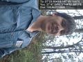
Success!
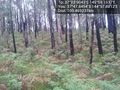
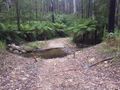
Photo of the geohash - note the blackened trees from some previous bushfire.
The 4 wheel drive track.
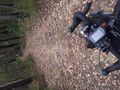
Proof
This would have been a great spot to fill up water bottles.
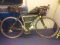
Gratuitous bike shot. This is on the train home on the day after.


Achievements
- Land geohash
- Bike Geohash?
Note: Calculating elevation gain is not straightforward. Strava gives 4840m, BRouter gives 3512.
Stevage earned the Colossal Climb achievement
|