2013-03-11 35 -92
| Mon 11 Mar 2013 in Conway: 35.1053049, -92.5454309 geohashing.info google osm bing/os kml crox |
Location
In the brambles of Cadron Settlement Park in Conway, AR.
Participants
Expedition
This one was too good to pass up, even for a weekday, so off we went to another geohashing adventure!
Reaching the park itself was easy enough, though it involved taking some roads we usually don't. While dividing attention between the GPS' statements of how close we were to the hashpoint and looking for a place to park, we went one parking lot further than was necessary- and instantly recognized it. This was the parking lot we'd parked in trying to reach a hash two weeks ago! We just hadn't recognized the park until then because we'd gone in from a different direction last time. We decided to park in the same parking lot as the last time we'd visited, even though it wasn't the closest to the hashpoint, just because.
We found trails leading near the hashpoint soon enough, but reaching the point itself was more complicated. For starters, Haberdasher, the one appointed to determine directions, has the amazing ability to get directions wrong with both the sun and the GPS guiding her, so that led to some extra time tramping around westward rather than eastward. (It did, however, lead to AshtaraSilunar finding a large green glass bottle, which she picked up and disposed of.) Even once directions were determined, there were quite a few branches to duck under and around in reaching the hashpoint. And then there was the Snarl.
The Snarl was what looked like the remains of a small tree, almost exactly where the hashpoint was, and thus blocking our path to it. We considered looping around and taking another trail to avoid dealing with the Snarl, but having already dealt with a good deal of branches, that idea was vetoed. The area around it was filled fairly densely with branches, making going around the Snarl a poor option as well. AshtaraSilunar was the one who came up with a working plan for getting to the hashpoint despite the Snarl- with a bit of careful balancing, you could step on the non-rotten parts of the trunk which made up the Snarl, then jump to the ground below. Upon doing so, we were practically on top of the hashpoint. Haberdasher joined the anti-littering cause by picking up an old, rusty/dirty can of Mello Yellow that was not far from the hashpoint.
After re-entering the trail, Haberdasher wanted to look for the Arkansas River and take pictures of it, as it was both likely to be pretty and was often the bane of her geohashing existence. (Due to the positioning of the roads around here, a hash just barely on the wrong side of the Arkansas River requires about double the time to reach, making such expeditions unlikely.) Following the trails around gave us only fleeting and partially-blocked views of the river, but upon nearing where we had entered the trail, we found a look-out which gave a good view of this beautiful if frustrating landmark.
Heading back required walking uphill on the same paved road which we'd walked on two weeks ago, also at the end of the expedition. The hashpoint was about 500 feet from our closest approach, but the connection was still an obvious one, and made moreso by passing familiar landmarks on our somewhat-convoluted path home.
Pictures

Litter retrieved
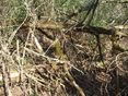
The Snarl
Hashpoint reached!

Ashtara's Stupid Grin

Haberdasher's Stupid Grin
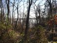
River from behind trees
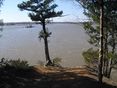
Arkansas River


Achievements
Haberdasher and AshtaraSilunar earned the Like a Virgin Geohash Achievement
|
Haberdasher and AshtaraSilunar issued a challenge for the Tale of Two Hashes achievement
|
AshtaraSilunar and Haberdasher earned the GeoTrash Geohash Achievement
|
Haberdasher achieved level 2 of the Minesweeper Geohash achievement
|
AshtaraSilunar achieved level 1 of the Minesweeper Geohash achievement
|
Haberdasher and AshtaraSilunar earned the Déjà Vu Geohash Achievement
|