2013-04-02 47 -122
| Tue 2 Apr 2013 in Seattle: 47.7180351, -122.0166102 geohashing.info google osm bing/os kml crox |
Location
Off 242nd Ave in Redmond, near the top of the bluff overlooking Duvall. Just south of the Tolt Pipeline Trail.
Participants
Plans
Stop by after work, roughly 4:30.
Expedition
- On my way - eta 4:10 pm -- Thomcat (talk) @47.7618,-122.1316 15:43, 2 April 2013 (PDT)
A bit of a winding drive, and very much the wrong way from home, but worth it for a geohash! I saw a few spots where one might hike a bit to see over the bluff, but it also looked like private property, so I demured. I crossed the Tolt Pipeline trail (really an access road - though the evidence of plenty of horses indicates it is multi-use) and soon arrived on the spot.
- Here we are! -- Thomcat (talk) @47.7180,-122.0166 16:04, 2 April 2013 (PDT)
I got out, snapped a few pics, and completely forgot to chalk the pavement. Rain threatening (which only happens here in months that have 3 or more letters), I decided to head for home. No meetup, but +1 success!
Photos
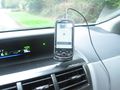
Parked on the spot

On the spot @47.7180,-122.0166
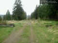
Tolt pipeline trail SE facing @47.7198,-122.0166
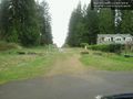
Tolt trail NW facing @47.7198,-122.0166


