2013-04-14 66 25
From Geohashing

| Sun 14 Apr 2013 in 66,25: 66.5239406, 25.7271735 geohashing.info google osm bing/os kml crox |
Contents
[hide]Location
On the island of the river "Ounasjoki", easy to reach. About 5 km from my home.
Participants
Expedition
- By car total 10 km
- Walking total 1.0 km
- Expedition took 1 h
- Physical effort (1-5): 2
My expedition started about 6:30 p.m. I could drive very close to the Hash, had to walk only 500 meters across the river.
Photos

The Proof
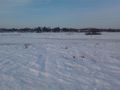
View to the east from the hash.
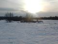
View to the west from the hash.
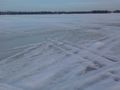
Icy river.


Achievements
isopekka earned the Land geohash achievement
|
Geohashing Expeditions and Plans on This Day
Expeditions and Plans
| 2013-04-14 | ||
|---|---|---|
| Ballarat, Australia | Snaplatitude, a lady friend | on the side of Chisolmes Road, Cardigan |
| Harrisburg, Pennsylvania | namAehT | This hash landed on top of a mountain, near a clear cut section of forest. |
| Dubuque, Iowa | Swensonj | Along NW Arterial near John F. Kennedy Road, Dubuque, Iowa. |
| Zürich, Switzerland | Chris 47 8 | Just outside winterthur, a forest near a motorway. |
| Northampton, United Kingdom | Sourcerer | 3) In a grassy meadow north west of Corby beside a disused railway. |
| Birmingham, United Kingdom | Sourcerer | 2) On the banks of the river Blythe between the M6 Toll road and the A446, ... |
| Shrewsbury, United Kingdom | Sourcerer | 1) About halfway between Shrewsbury and Ludlow, Shropshire UK, the hashpoin... |
| Cambridge, United Kingdom | Sourcerer | 4) In a military zone used for training. Normally, there is no public acces... |
| Norwich, United Kingdom | Sourcerer | 5) In a wheat field between the A12 and the coast north of Lowestoft, Suffo... |
| Rovaniemi, Finland | isopekka | On the island of the river "Ounasjoki", easy to reach. About 5 km from my h... |