2013-04-19 26 -80
| Fri 19 Apr 2013 in 26,-80: 26.3154750, -80.2787965 geohashing.info google osm bing/os kml crox |
Location
In the right-hand north-bound lane of Nob Hill Road in Parkland.
Participants
Plans
This hashpoint was about 6 miles north of me, and in the wrong direction for my morning commute. I drove there before work, anyway.
Expedition
I drove up for an obvious and easy Speed Racer. I must have driven through it on my first attempt due north (I was in the right lane well before I reached it), but I lost track of that on GeohashDroid on the way. Then I circled around again and pulled over close to the hashpoint for pictures and a close GPS read on my phone.
Before heading out I had noticed an odd arrangement of hedges very near the hashpoint, but I didn't investigate it closely on the map. When I got there, I saw that the hedges were camouflage for some kind of utility installation, but there was nothing actually installed besides an unconnected pipe.
Photos
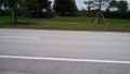
The hashpoint is in the right-hand lane, closest to me.
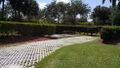
The unused utility site.


Achievements
Million_zillion earned the Speed racer achievement
|