2013-05-09 52 5
| Thu 9 May 2013 in Utrecht: 52.1637194, 5.7544208 geohashing.info google osm bing/os kml crox |
Location
The coordinates lie in the middle of a forest in the Veluwe region in the Netherlands, south of the town of Kootwijk. Almost immediately adjacent to the east was the Kootwijkerzand dune area.
Participants
Blauwe BIC, dragging along a non-registered invitee.
Plans
This day is Ascension Day, a bank holiday in the Netherlands when Christians commemorate the ascension of Jesus. An old tradition in the Netherlands is to go "dauwtrappen" (translates to something like "dew stepping"), simply comprising getting up early to take a walk into nature. Getting up very early. Something like 3 AM. Out of multiple graticules around my home location, we picked this destination to step on some dew.
Expedition
After surviving the first obstacle of our expedition, actually getting up at 3 AM, we took the car to drive to Kootwijk. Before sunrise, we were not permitted to proceed on the final road leading into the forest to a small parking space reasonably near the coordinates. So before proceeding to the coordinates, we took a small detour to an interesting landmark several kilometers to the east. In the 1920s, a very low frequency radio transmitter was built to enable direct communication with Dutch East India (present day Indonesia). The building supporting the radio transmitter array is still present, right in the middle of an open space in the forest. Light conditions were insufficient to take pictures, but for an impression, take a look here.
After a short walk and sufficient sunrise, we took the car back to the car park near the coordinates, and continued on foot.
There was a path through the forest passing the coordinates off by a few dozen meters. There was also a desert-like area to the east, and we decided to wander through the sand, to return to the forest as close to the coordinates as possible. The tree and shrub density was low enough to allow us to continue in an almost straight line. The accuracy of my phone's GPS app was not optimal, albeit reasonable to determine that we were close enough at a certain point to consider our destination reached.
Tracklog
Photos
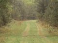
The nearest road, although we only took this on the way back.
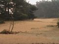
We wandered through this desert-like area (prettier panorama photo here)
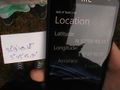
Decided that we made it; there were no obstacles around that would have prevented us to be anywhere within the 8 meter radius.


Achievements
Blauwe BIC earned the Land geohash achievement
|
Blauwe BIC earned the Drag-along achievement
|