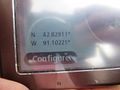
2013-05-11 42 -91
| Sat 11 May 2013 in 42,-91: 42.8291249, -91.1022332 geohashing.info google osm bing/os kml crox |
Location
Timberlane Road north of 3rd Avenue, Guttenberg, Iowa; about 200m west of the Mississippi River.
Participants
Plans
Let's try for an XKCD meetup: 4:00 p.m.
Expedition

We (SwensonJ, with wife, son, and daughter) left Platteville in the early afternoon. According to the Small Hash inquiry tool, today's hashpoint was about 32 miles from our home. Unfortunately, the Mississippi River makes a straight-line approach difficult.
At first, we were hoping to cross the river on the Cassville Car Ferry, but it turned out that the ferry isn't running, because the Mississippi is at flood stage. We had to cross at Dubuque, which makes it about a 65-mile trip from our house. The weather was fairly warm, but with a cold wind -- the sky was summery, a mix of bright blue and giant white rainclouds. It stayed dry, though, and we enjoyed the drive along roads we'd never traveled before.
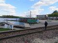
We were within striking distance of the hash about 20 minutes early, so we drove about half a mile up and out of town to the north, and found an overlook, where we could pull off the highway and take our picture overlooking the river. We got to watch a barge coming upriver, in the last stages of passing through the lock and dam.
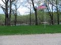
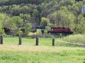
The hashpoint is in or near Guttenberg, Iowa, beside a north-south road on a narrow strip of land between a railroad track and the river. From Google's satellite image, you can't tell that anything is there, but there are actually homes on the west side of the road; the hash was in someone's side yard. As it was fairly distant from the houses, and unfenced, I did get out and try to get to the right coordinates, but I felt inhibited about doing an extended GPS dance, so my proof photo shows a position that's a couple of ten-thousandths of a degree away from the exact position. We retreated to the van and hung out until 4:00. It seemed like a neighborhood where loiterers would be asked questions, though, and we weren't expecting anyone to meet us, so we took off and went looking for a spot by the river for a quick picnic snack.
Along the way, my son spotted an oriole, and we stopped to try for a photo, but without much success. We all got a good look at it, though, which was fun: orioles are not very common around here. We drove down by the town's football stadium, and parked just south of their disused soccer field. The frames of the soccer goals are recognizable in one of the photos we took from the overlook, in fact.
While eating, we got to watch a freight train pass. My son stopped counting cars at 123. My wife was more interested in the fact that the train was definitely slowing: a stopped train would have cut us off from what I'd started to think of as the "mainland." We were happy to see the end of the train roll past.
The picnic was interrupted after five or ten minutes by a quick sprinkling of rain, in which we were startled to feel a few particles of freezing sleet. As soon as we were back in the van, though, the shower stopped. We left anyway, and headed north towards Marquette, Iowa, where there's a bridge back to Wisconsin.
We stopped for dinner impulsively in McGregor, Iowa, when we saw a burger joint along the river with its dining room actually built over the water. The food was fine, and the view was good; we got to watch a bald eagle land in a tree on an island bar, far out in the river. After dinner, we drove the rest of the way home without a stop, through country that's much more familiar to us. We got home at about 7:30; the family agreed that it had been one of our best geohashing expeditions.
Photos
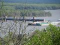
The barge coming upriver out of Lock and Dam #10
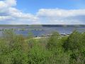
A view down into Guttenberg, Iowa
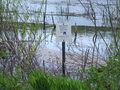
The hash was in a section of town sandwiched between the river and a wildlife refuge
We went to the right place!
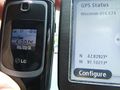
We were there for the XKCD meetup time
The hashpoint, as seen from our van
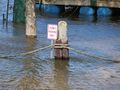
The river was higher than normal
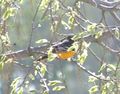
My best photo of the oriole
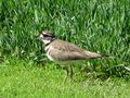
A small wading bird
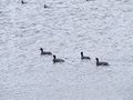
Unfamiliar black ducks with white bills
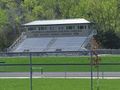
Guttenberg's football field
SwensonJ and kids celebrate a successful hash
The train that temporarily cut off our escape
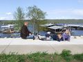
We ate here, on the river
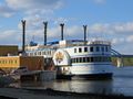
Behind this riverboat casino, you can see the bridge from which we photographed the same casino on 2012-10-06
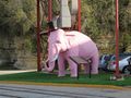
The casino's mascot?
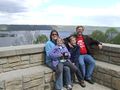
The family portrait


Achievements
SwensonJ earned the Land geohash achievement
|
SwensonJ earned the xkcd Nullaturion achievement
|