2013-05-21 42 -89
| Tue 21 May 2013 in 42,-89: 42.6250937, -89.8231275 geohashing.info google osm bing/os kml crox |
Location
Dog Hollow Road between Jordan-Wiota Road and Duncan Hill Road; Jordan Township, Green County, Wisconsin
Participants
Plans
Celebrating Geohashing Day in rural Wisconsin -- sometime between 3:00 and 4:00.
Expedition

(This is the second in a string of consecutive geohashes: see previous or next.)
Before the coordinates were even available, I had decided I was definitely going to visit a hashpoint this year on Geohashing Day. The rest of my family was busy with work/school, so I left by myself around 2 p.m. The sky was overcast, and thunderstorms looked like a definite possibility, but after an hour's drive, the clouds were breaking up and the feeling of summer was sneaking into southwest Wisconsin.
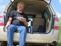
The hashpoint was on the south shoulder of the picturesquely-named Dog Hollow Road. (To get there, I took Roller Coaster Road, which I'd first discovered on the way to 2012-10-13_42_-89.) I accidentally left my mini-tripod in the van, so I took my Stupid Grin self-portrait by hanging the camera by its wrist strap from a barbed wire fence. All things considered, I thought it came out fairly well.
The GPS is not doing as good of a job. A recent software update seems to have made it less sensitive, and/or made it check its position less frequently. I used to be able to find my position accurate to a hundred-thousandth of a degree without working too hard. Now I struggle to get readings that are within a couple of meters.
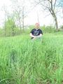
After a few photos, I took the time to enjoy a cup of coffee and a slice of Geohashing Day cake. I'd also bought half a pie, in a blatant grab at the Pie Geohash achievement -- but I hadn't read the rules first. I would have had to bake the pie myself, and share it with others. It was good anyway.
I didn't see a single person in all the time I was at the hash; apparently Dog Hollow Road is not very active on weekday afternoons. I read a book until about 3:40, when I needed to get back on the road to meet my family for evening activities. The ride back was uneventful; I saw a big turkey fairly near the road, but he wouldn't pose for a photo. The wildlife is easier to spot at this time of the year, when the corn is about 3 inches tall, than it will be when summer comes for real.
Photos
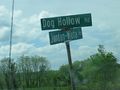
Low-tech location cue: getting close!

I was there...
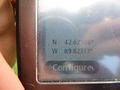
...at least +/- 1 m...
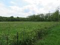
View south from the road
It was a good day for a geohash.
A bit of prior planning allowed me...
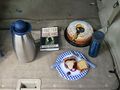
...to celebrate Geohashing Day in style!
On the way home, I drove through fast.


Achievements
SwensonJ earned the Land geohash achievement
|
SwensonJ earned the Consecutive geohash achievement
|
SwensonJ earned the 2013 Geohashing Day achievement
|
SwensonJ earned the Speed racer achievement
|
SwensonJ issued a challenge for the Tale of Two Hashes achievement
|