2013-06-30 52 -0
| Sun 30 Jun 2013 in 52,-0: 52.2266635, -0.2867590 geohashing.info google osm bing/os kml crox |
Location
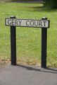
The end of Gery Court in Eaton Ford, about one mile west of St. Neots town centre.
Participants
- PaintedJaguar
- MrsPaintedJaguar
Plans
PaintedJaguar and MrsPaintedJaguar plan to catch an X5 bus from Cambridge to St. Neots at 10:30 in the morning, and then walk from St. Neots town centre to the hashpoint, arriving at about 11:30. They then plan to spend the afternoon exploring the nearby Paxton Pits Nature Reserve.
Expedition
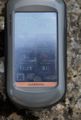
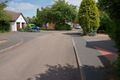
This really was an easy expedition. The bus into Cambridge town centre arrived on time. The X5 to St. Neots arrived on time. The walk to the hashpoint from St. Neots town centre was very easy, with no chance of getting lost, and we easily got to within the error margin of the GPS (5 metres from the hashpoint with an error of 7 metres). This was at the very beginning of somebody's driveway, with trees overhead and adjacent to a building, so any attempt to move the GPS around to get a closer reading resulted in the accuracy level dropping right down. After walking randomly around the start of the driveway for a while, we settled for what we had, and wrote an XKCD message in chalk on the pavement at the end of the drive, and took the obligatory silly grin photo with our usual hashscot, Hammersmith the pink caterpillar.
At this point, one of the people who lived on the road, and was out chatting with their neighbours, came over and asked us what we were doing. This was the first time we'd ever had interaction with people "not from the internet" whilst actually at a hashpoint. We gave a brief explanation of geohashing, which seemed to get an acceptable, if slightly puzzled, response. However, after we described our plans to head to Paxton Pits Nature Reserve, they seemed to decide that we were probably fairly normal people after all, and advised us about our afternoon plans, since they'd visited the nature reserve themselves in the past.
We then headed back into St. Neots, and out along the River Great Ouse to Paxton, where we had a thoroughly enjoyable afternoon watching cormorants, grebes, kingfishers and herons (amongst various other more common water-birds) whilst walking around the numerous lakes. It was a very hot afternoon, and we finished off the day by heading back into St. Neots, where we had a very nice meal and well-deserved pint in The Bridge House pub.
Tracklog
http://www.wikiloc.com/wikiloc/view.do?id=4964320 - we only realised afterwards how close this was to a Juggernaut achievement, but analysing the tracklog shows that we deviated just a bit too much to claim this.
Photos
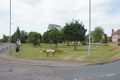
Eaton Ford village green
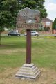
Eaton Ford village sign
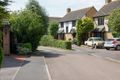
Reached the right road...
The hashpoint is at the end of the road
At the hashpoint

Silly grins
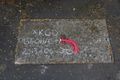
XKCD marker
View back down the road from the hashpoint
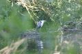
Heron at Paxton Pits

Proof of public transport achievement


Achievements
PaintedJaguar earned the Land geohash achievement
|
PaintedJaguar earned the Public transport geohash achievement
|
PaintedJaguar earned the Regional geohashing achievement
|