2013-09-04 49 9
| Wed 4 Sep 2013 in Würzburg: 49.6468554, 9.6410407 geohashing.info google osm bing/os kml crox |
Location
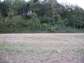
Today's location is at the edge of a forest near Tauberbischofsheim.
Country: Germany; state: Baden-Württemberg (EU:DE:BW); administrative region: Stuttgart; district: Main-Tauber-Kreis
Weather: Sunny
Expedition
Danatar
Okay, birthday means geohashing, so I knew what to do. But this year it was more difficult than before... One thing was that my colleague was on vacation and I had to do his part of the work, which led to overtime. The other thing was the upcoming wedding of one of my best friends on the following weekend and I had to prepare something very important. I was very stressed, so I didn't have the time to make a birthday cake, neither for work nor for the expedition. But, as I said before, birthday means geohashing.
I drove along the Autobahn to Tauberbischofsheim and without any problems reached the base of the hashhill where I parked the car. From the satellite image I knew that I had to walk a little detour to get to the hashpoint and I decided to take the clockwise route. The first track went up along the hillside with forest on my right and fields below me on my left. After a short time I could see that the track would go on for a long while away from the hashpoint and I decided to take a shortcut. If I had taken a better look at the satellite image before starting (instead of just printing the region near the hashpoint) much difficulty could have been avoided. I climbed uphill through the forest which at first was not very dense. The edge on the other side however was filled with thick shrubbery and thorny plants. After many tries I found a place where I could crawl (not on my stomach, but almost) under low-hanging thorny branches to the other side. Why am I doing this again?
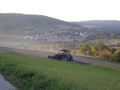
A sunlit field greeted me and I walked along its edge to the next field track, then followed that until I came near the hashpoint. A bit further along the track a farmer was preparing (harrowing I think) his field, driving back and forth with his tractor. From the satellite image I knew that the spot would be directly at the edge of the forest and I walked right towards it. When I reached the thick bushes, the GPS told me "six more steps for correct LON coordinates" (not pictured). Waiting for the hashpoint to come to me didn't work :-( I didn't crawl through bushes getting dirty to miss my birthday hashpoint, so I looked for the nearest breach in the bushes and started crawling again, here it was easier. I reached the spot about 2 metres inside the shrubbery. After taking the usual pictures (the panorama compiler didn't work because of the too many near branches) and eating celebratory Nibs I took the short way out of the shrubbery, the GPS spot had moved nearer to the edge by that time. Hooray, I did it!
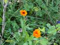
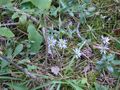
Because I didn't want to take the same way back through the thick forest I continued on a clockwise route. I knew that only a thin (at satellite image resolution) line of bushes separated me from a track that would lead directly to my car, so I just walked to that line of shrubbery and… found them to be very dense, no way through here. Maybe a few metres further… no. A few more… no. More… no. Only after about 350 m I saw a way through, this led me to a small meadow with many colorful flowers. (I was already beyond my printed map or else I would have seen that the bushes ended another 200 m further.) From there it was just straight ahead along a small track with high bushes on both sides. For the fraction of a second I saw a large animal (probably a deer) before it disappeared out of sight. After a while I found a sign telling "beware of bees" and reached an area with dozens of beehives, many of them very busy. Then I reached my car and drove home, spontaneously visiting the wine festival with friends in the evening. The walking part of the expedition had taken only one hour, although it had felt like at least two.
Danatar earned the Birthday Geohash Achievement
|
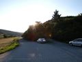
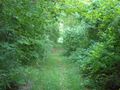
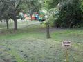
I started walking from here...
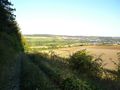
...up along this track...
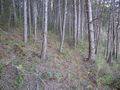
...through this forest.
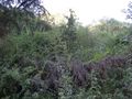
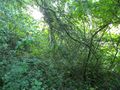
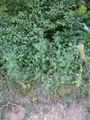
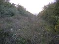
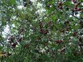
When blocked by this bushes...
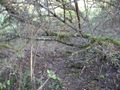
...I crawled through this...
...and this.
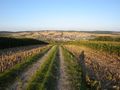
Then along these...
...tracks until I was...
...almost there.
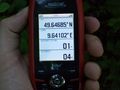
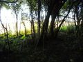
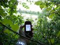
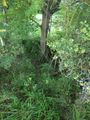
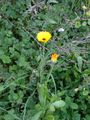
I reached the...
...hashpoint...
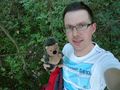
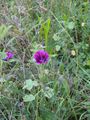
...and celebrated.
Then the hashpoint moved...
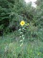
...and I came out of the underbrush...
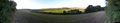
...to this semi-panorama.
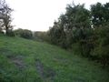
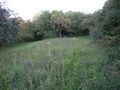
This hedge was inpenetrable...
...so I had to cross this overgrown meadow...
...until I found a way through it...
...to here.
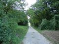
From there it was just along another track...
...and past the bees,...
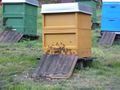
...many bees.
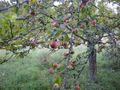
apples


tracklog
other
I wasn't able to visit my hashiversary location three days after this expedition because of the aforementioned wedding. I had a route planned (for 2013-09-07 50 10) and a small cake prepared, but work in the morning and the last preparations for the wedding took all the time I had available and even so I was almost late for the ceremony. So I missed my hashiversary for the first time. In the past almost-year, my fifth year of geohashing, I:
- visited another 9 hashpoints (out of 9 tries)
- cycled 97.7 km, walked 19.9 km, used public transport for 201.7 km and motorized vehicles for 95.3 km
- spent another 53 Euros while geohashing
This is getting less every year, probably because I'm getting old...