2013-10-19 40 0
| Sat 19 Oct 2013 in 40,0: 40.8302104, 0.6963933 geohashing.info google osm bing/os kml crox |
Location
In an olive grove near L'Ampolla, Spain.
Participants
- Pastori
- The Wife
Expedition
(Pastori's European tour begins here.) (Previous expedition on tour here.)

Pastori's and The Wife's South European tournée continued still further south, and we reached the southwesternmost spot of Europe. There was only ocean ahead, so had to turn eastward.
The journey went along in warm and sunny mood, the only cloud in the sky was a small road accident in a traffic circle in the last leg of driving in Portugal. During the week they spent in Marbesa, Spain, Pastori and The Wife made a wandering to a geocache and deposited there an eternally moving geocoin, which the Editor had found in Finland and given to them. After a visit in Gibraltar we finally turned northwards and our next place of stay, and of course a hashpoint!

There was a suitable point along our way with only a couple of kilometers detour from the motorway. Small unpaved roads went through olive groves, and after many bends we reached the point, zero meters from it, according to the car satnav. But Pastori's more accurate program in his smartphone once again showed some weird readings, this time it suggested we were still 117 km from the point. So we were ourselves not sure anymore were the exact point might have been. Excuse me, Editor, is the fault in Pastori, the satellites or the program? [*Editor's response at the end] Nevertheless, this seems to be a point of misfortune. But Pastori and The Wife were there.

Going back to the main road didn't succeed the better. Suddenly we were faced with about 45 degrees downslope, and in that point we had to shift into reverse. We were totally lost and the satnav didn't offer any safer routes. So we just had to continue and eventually our adventure ended as we got out from the maze in the same bend we had entered the gravel road. Phew!
There is still couple of weeks left in Pastori's and The Wife's journey, let's see if any more hashpoints line up in the way.
[Editor's note: Probably Pastori was the one that was mistaken :). The distance of 117 km is about the length of a graticule at 40 degrees latitude. (Weird though, it should be 111 km, but perhaps that program is not good at calculating such long distances.) So Pastori has probably made an error while entering the coordinates of the target point. Good thing is, that the picture of the screen you've provided, proves that you were within 44 meters of the correct target. The target would have been 38 meters south and 22 meters east. (Quite accurate that positioning of Google's satellite imagery in Spain, I estimated beforehand that the hashpoint should be about 20 meters from the road.) Thus I have to mark this as a failure to reach the point. But you'll receive a Blinded by Science consolation prize!]
Our journey continues to Germany.
Additional pictures
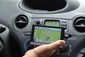
The satnav picture.

Proof of (almost) getting there.


Achievements
Pastori earned the Blinded by Science Consolation Prize
|