2013-10-29 52 10
| Tue 29 Oct 2013 in 52,10: 52.1365916, 10.0768089 geohashing.info google osm bing/os kml crox |
Location
In a field in Wendhausen.
Participants
- Pastori
- The Wife
Expedition
(Pastori's European tour begins here.) (The previous expedition on tour here.)

After a failure Pastori's and The Wife's journey continued towards north and the Baltic Sea. The night had passed well in Waldwinkel Lodge. The place was Bad Grund, which prepared Pastori and The Wife nicely for the return home. It was a lonely place, in the middle of a forest and we didn't hear any sounds nor see any lights at the nighttime. Felt exactly like home!
On our last day of travel Pastori was determined - we had to conquer Germany now. The first suitable hashpoint was after 50 km with only a small detour of 2 km from the motorway. The point was in a field in small village called Wendhausen between Holle and Hildesheim.

Ok, so we were on the way and the car satnav instructed us to turn right, but because there seemed to be a service station there, Pastori didn't want to turn there and thus we were immediately off our target. Pastori has to his defence the fact that he had driven so long along the toll motorways, which have only carefully fenced resting places, from which there is no access to any other roads, that it didn't cross his mind that this would be the right exit. But surprise surprise, after a u-turn made at the next exit 10 km away, we found the right village road which indeed started from the rest area.

The point seemed to be on an open field, so Pastori put on his old trusty Nokia boots, which he had dragged along the whole tour. The field was sown, and the soil adhered nicely to the boots, so Wife remained on the edge of the field in a photographing position. Pastori did a little geodance, and there the point was! The closest screenshot to the smartphone was at about 8 m. Excited about this, Pastori sent some smoke signals to his Wife at 100 meters away that he had found the point. With very happy mood, they continued to Travemünde harbor to wait for their ferry, which was 5 hours late because of the storm that went over Europe.

Thus far we have driven 9933 km, and there is a 30 hours ferry trip to Helsinki ahead, from where there is about 600 km to home. It remains to be seen, when Pastori and The Wife have recovered enough from this trip and have the strength to go the hashpoints in their home graticule. To all of you following our journey: have a nice fall and winter - and a lot of hashing!
Additional pictures
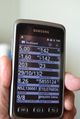
The GPS proof.

Achievements
Pastori and The Wife earned the Land geohash achievement
|