2013-12-11 62 27
| Wed 11 Dec 2013 in 62,27: 62.8592477, 27.6613167 geohashing.info google osm bing/os kml crox |
Location
In Kuopio, on the ice of lake Kallavesi. Small bay of Ruokolahti near Rauhalahti.
Participants
Expedition

Again a hash very close, only 1,6 km from my home. Actually, this the second closest hashpoint in this graticule after I began tracking hashpoints a little more than a year ago. (The closest is this globalhash.) So this was a must visit. A little excitement was caused by the fact that the hashpoint was again on ice - this time on the big lake Kallavesi. Fortunately the point lies on a very small bay only about 300 meters wide, with no notable creeks or streamlets. Additionally there has been recently a few days with very cold temperatures, over -20°C, so I was fairly confident there would be a thick ice already.

This day, however, was very warm, with plus degrees right on the morning. After breakfast, me and my wife and daughter went to Kuopio city center for some christmas shopping and random errands. We also had a meal, and got home about the time of sunset, 14:33. So after 20 km of cargobiking I just quickly changed clothes, packed some stuff into backpack and headed right back outside. I grabbed my swedish-army-surplus cross-country skis from the shed and the expedition had started.
I walked about 200 meters to the beginning of the ski track, and put the skis on. The ski track isn't actually maintained yet, that's why I chose the heavier skis. After few hundred meters there was two options. I could take off skis and walk again some distance, or I could cross another bay of the big lake. There weren't any (human) tracks on the snow that covered the ice, but I opted for the ice crossing anyway. I wanted to see how these kind of bays have iced, because here I could stay very close to the shore. When going for the actual hashpoint, I would have to be at least 100 meters from the ground.
The ice was a good choice. I couldn't feel any weaknesses, and the view towards the setting sun was spectacular! Some high clouds were still on the sunlight, and presented a magnificent light show. Too bad I had to ski ahead with my back against this, but I turned now and then to admire it. The clouds got more red tones every minute. An untouched snow/ice field lay in front of me, as I glided forward. A really wonderful nature experience even so close to the city.
Nearing the end of crossing, there was about 3-5 cm water on the ice. I slowed down my pace, as this might indicate some weakness on the ice where the water had gotten through. The ice beneath the water was fortunately solid and I got safely to the ground. Then I skied about a kilometer on the unmaintained ski track, after which I turned into a forest path, that I knew from summer mountain biking trips to be leading to the shore of the bay, which was closer to the hashpoint. Quickly I reached the edge of water, and after navigating through some thickety shore vegetation, I began my second ice stretch, with about 300 meters to the hashpoint.

There was water also here on the ice, but I advanced steadily. Now the light was really starting to fade, with clouds very red above the tree line. The ice felt strong, and soon I reached the hashpoint. The snow surface was unspoiled, nobody had definitely been here before me. The reception was excellent, and I just had to wait about half a minute before the gps got an exact fix on my location, and the device showed 0,00 meters to the point! First time in my hashing career btw. However, I didn't get a picture of that, and had to settle for a mere 0,17 meters of documented accuracy.

With the most important proof secured, I got into some fun activities. This time I was determined to find out how thick the ice actually was, and had packed some equipment for that. Therefore I first took my german-army-surplus field spade and cleared the ice from its cover consisting of 10 cm of snow and 5 cm of slush. The I took my axe and made a hole into the ice. It turned out to be a little over 10 cm thick. The structure of the ice was not pure solid ice, but it also had some porous ice on top. However, I was much on the safe side, even 5 cm of this kind of ice would have probably been enough. When my axe breaked the bottom of the ice, the hole I had made was immediately filled with water rising from the lake. I tested the watertightness of my gps device by submerging it into the water. Did you know that the GPS reception gets much poorer if the device is underwater? Or is it the walls of the icy hole that blocked the signal?

After this examination of ice, I left a marker, that is I shoveled the letters KCD (with my skis acting as X) to the snow, and took a picture. The darkness was falling, so I gathered my equipment and returned along my own tracks. I didn't want to take any chances by crossing the bay straight to the other side. Right in the middle of the bay, if anywhere, there could more likely be some water moving and the ice could be shallower. So back through the thickets, along the ground stretch, then again to the ice of the another bay, back to land from there and soon I was home. A very nice, peaceful trip, that had also some extreme feelings when crossing unknown ice.
Additional photos

The pose.
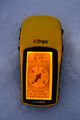
GPS proof.
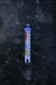
Yup. Ice is definitely frozen.
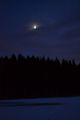
Moon was shining from behind some clouds.


Achievements
Tilley earned the cross-country skiing achievement
|
Tilley earned the Walking on water geohash achievement
|
Tilley earned the Frozen Geohash Achievement
|