2013-11-30 global
|
Globalhash on Sat 30 Nov 2013: |
Location
On the lake in the middle of suburban area.
Participants
Expedition 1:
Expedition 2:
Expedition 1
Report
I got the news of this handy set of coordinates by Rex Wolf, who begged and pleaded me to go and grab it. Sure, why not, I thought, and started digging in for more information about it. When at first I couldn't match the location for any hashes for the date, I started wondering what's wrong with this... and then I figured it out. It's a Globalhash, not your every day Geohash! Of course I'll go get it! And it couldn't be more conveniently placed anyway, since it was within 5 kilometer radius from my home. What a brilliant start for my geohashing career!
It was apparent that the coordinates were on the lake, and since we're still early in the winter, I doubted I could sneak close enough to get a proper grab of it. But since these things don't pop up every day in the neighbourhood, I figured getting within line of sight is good enough for me.
I started early, since the weather was getting gradually worse toward midday. I didn't quite escape the snow, but it wasn't too bad, just a mildly slippery drive to a nearby parking lot. The little forest area towards the hash point was littered with pathways, so it was a quick walk there.
It became quickly apparent that getting on the ice was definitely a no-go. Water around the trees along the shoreline hadn't frozen yet, so I couldn't really trust the ice any better, not with my usual weight-to-surface-area ratio. A little kick on the ice was pushing water up, so I decided to admire this magical location afar.
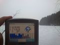
I quickly gathered some data from my locating devices (touchscreens get silly when wet), TomTom One (3rd ed.) was getting a decent view of satellites, and my Sony-Ericsson was getting some numbers as well. But in the end, GPS software said I was off about 45 meters, and little Excel magic back at home confirms that the closest I got was about 40 meters east of the spot.
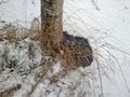
Interestingly, I noticed something on the ice about where the true location would be. Maybe some daredevil had gotten there before me? Or nature had provided a handy little marker in advance, how does she know?
I grabbed a couple of pictures for panoramas to stitch back at home, looked around in hopes of hordes of excited geohashers to arrive, and sneaked back to my car in the increasing snowfall. Close, but no cigar.
Photos
Arrived on site, snowing wasn't too bad yet.
Checked the ice, I'm not going there!
Started checking my devices, good old Tomtom...
... and GPS Essentials for my tinyphone.
Yeah, it's out there. And something else too...
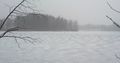
Looks like there's something out there on the ice. Marker? Wood? Early Geohashing bird?

Yeah, no Stupid Grin tm , I was getting snowflakes stuck in me teef.
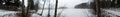
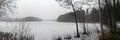
Wider shot of the area.
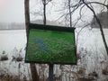
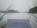
Also, signs were most helpful.


Expedition 2
Report
I had just come back from the expedition to the regular hashpoint in this graticule and started to write a report, when I saw the message from a fellow Finnish geohasher Suurnesu about this globalhash. First I was a bit sceptical about the "closeness" of the globalhash. The globalhash is such a big deal to most geohashers, that they will feel it's "close" even when it's dozens, even hundreds of kilometers away. The geohashing tool I use to check the hashpoints, peeron, doesn't show globalhashes, and mostly I haven't bothered checking them. The odds of one landing within bicycle range would be astronomically small.
Nevertheless, I opened gh.eupeodes.nl and started to search for Finland from the map. As I got closer, I quickly noticed there was this big red needle right on top of Kuopio! OMG! Is this for real? I started to zoom in, and my jaw just dropped lower and lower. Globalhash! And it's right here in my neighborhood! Only a kilometer from where I am sitting right now! Am I dreaming? I could hardly contain my excitement as I announced the news to my wife and my one-year-old daughter in the other room.

After a moment I started to calm down a bit. The only problem with the point was, that it was in the ice of a small lake called Levänen. The small lakes had only started to freeze about a week ago and the ice was still probably very thin and perilous. The day's previous encounter with ice wasn't promising at all. However, I was determined to do whatever it takes to reach this point. It was my duty to the entire geohashing community! So rarely has the globalhash fell within areas even this densely populated.
I quickly started pondering all sorts of options. Swimming? Although I have swam in a hole in the ice for some meters, the map suggested the point was about 50 meters into the lake, which was too long a distance. Should I build a raft? What materials do I have here ? A wooden pallet and some planks, tarpaulin and empty plastic bottles. Would that be enough to float me? Probably not. The bottles I have would barely float the heavy pallet. How about borrowing a rowing boat? There are some in that lake, I've seen them. But would people consider me insane for borrowing a boat to row on a frozen lake? Probably. There was still time, about 10 hours, even for the most illusionary projects..

One problem was nevertheless the fading light outside. In these latitudes and this time of year, the Sun sets early. Actually it had already set, at 14:47. And trying to sail a home-made raft, at the same time crushing ice, in almost complete darkness, was probably not the best idea. I quickly came to a conclusion. My best bet at getting to the point was to hope that the ice would, despite all, be strong enough to walk on. At least I would have to go the spot and see for myself, what the conditions were. After all, It was only a kilometer away. I could then plan further.
I therefore started to gather some equipment. I had some paddling equipment in my home, although our kayaks were already in their winter storage. What do we have here? Neoprene wrist warmers, neoprene shoes. A watertight packing sack. 10 meters of rope. Watertight cell-phone case. Watertight case for the camera. GPS, in itself waterproof. This starts to sound a lot I'm planning to get desperate? Not at all. For the most important piece of equipment I grabbed from the shed: an ice pike! I figured I would use the technique of the nordic skaters: they punch the ice with a pike to test its thickness. This is done by both observing how deep the pike goes into the ice, and by what sound the ice makes when you punch it.
I was ready to go! I chose again my mountain bike, to which I quickly changed pedals to accommodate hiking boots. Now it really was a short ride, although the bicycle- and footpaths were in terrible condition. As I turned to the hiking path going around the lake and neared the point, my excitement grew again. How close the point really was to the shore? The reading got smaller and smaller. 60 meters. 40. 30! 25! At it's closest, the GPS showed only 16 meters when standing on the safe ground! Can that be? This seems promising - at least it's a lot less than 50 meters. I started to ready my equipment. Phone and camera to waterproof cases. The empty watertight sack I closed with only full of air and placed it inside my rucksack. The rucksack I then attached firmly to my waist with a strap. This is another safety technique the above-mentioned nordic skaters use.

I then grabbed my ice pike and stepped closer to the shore. There was a small gap of liquid water in the shore, but I ignored that and aimed for a little bit further. The first strike would tell me a lot. I hit the ice with a strong blow. Tschak! The ice held! Yes! This may work! I aimed more blows on the ice, and it seemed surprisingly thick. Even within few centimeters of the liquid water the ice held. I stepped over the gap and stood on the ice! There was no sounds of cracking nor any feel that the ice would be giving away. There is still one tree a couple of meters further - the water level on the lake seems quite high. I advanced to the tree carefully, a 10-cm-step at a time, hitting the ice with my pike as I go. Still no signs of the ice weakening. I deployed my third precautionary means, that is, I attached the rope to the tree and took the other end with me. Then I slowly and carefully advanced into the ice, hitting it constantly with my pike.

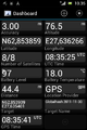
After a couple of meters I stopped and started looking at the GPS. The reception was very poor because of the heavy snowing. It said only 6 meters. I advanced 6 meters further, and read the screen again. Still 6 meters, this time towards the shore. I made a bit of a circle. The ice seemed very strong, and my tension started to relieve. I still didn't stop hitting the ice with the pike, there may be thinner patches. After I had GPS danced a bit with the help of the coordinate display, I got a reading of 1,5 meters to the target. I quickly took a photo. The globalhash is conquered! I then retraced my steps into the middle of the circle my tracks had made and erected my ice pike there to mark the symbolical point of the globalhash. It was probably my poor reception that brought the point closer to the shore, but the ice actually was really thick. With the ice pike, I would have dared to venture much further.

With the necessary proof safely inside the camera, I admired the snowy views for a while, and then took my telephone and called Pastori. I said: "You're never gonna guess where I am". And he didn't.
I then returned home, and on the way it occurred to me, that I should have walked to the point - I don't have that achievement yet. But then I remembered that the antarctica guys walked to globalhash - but has anyone biked there? :)
When home, I reported my success to the IRC channel. I then found out, that today a mysterious geohasher had suddenly appeared, Far! And he had already visited the vicinity of the point, but didn't trust the ice as much as I did and couldn't get there. What a coincidence! Or is it the globalhash's magic that it draws geohashers like honey draws flies?
Additional Photos
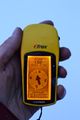
The gps proof. Of the globalhash!
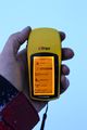
The time and date.


Achievements:
Tilley earned the Globalhash achievement
|
Tilley earned the Walking on water geohash achievement
|
Tilley earned the Bicycle geohash achievement
|
Tilley earned the Frozen Geohash Achievement
|
(Does it count if I provide a picture of my home thermometer for proof, since the point really is only a kilometer from here?)
Tilley earned the Multihash Achievement
|