2013-11-30 62 27
| Sat 30 Nov 2013 in 62,27: 62.8491884, 27.5767650 geohashing.info google osm bing/os kml crox |
Location
In Pieni Neulamäki, Kuopio. The point is in forest.
Participants
Expedition
What an exciting geohashing day this has been! But let's start from the beginning...
Yesterday I checked the weekend's hashpoints, and found to my delight that Saturday's point was very near. Only 3,6 km from my home as the bird flies, and accessible, too. The point was only a few hundred meters from this point, along the same road. So it was a must to visit the point, it was only a matter of planning the logistics for the day to make that happen. In the morning, 9 am, me and my daughter would go to the baby swimming in Kuopio swimming hall in the city center, and for a moment I considered we would go to the hashpoint directly from there. That would have saved about 5 km of biking, but as I didn't know the condition of the small gravel road I would have to take, I decided I would bring the baby home, eat some lunch and then leave again for the hashpoint. This would make day's total cycling distance a little less than 30 km.

When cycling to the baby swimming on our child-transport-bike, the sky was almost clear. The forecast said snow, and, indeed, during the hour we spent inside the swimming hall, it had started to snow. As I cycled homewards in the brisk 6 m/s headwind, the snowing got thicker all the time. As usual, I parked outside our kitchen window to let my daughter sleep in the protection of the bike canopy under some blankets (In Finland it's very normal to let the children sleep outside even in winter. See this study.) While eating my lunch, the snowing outside still got thicker and even the canopy window started to get covered. As the window was almost covered, the baby woke and I brought her in.

Then it was only a matter of deciding which bike I would take, before the expedition could began. The autumn here had been relatively warm, and we had had decent sub-zero Celsius temperatures only for a couple of weeks. In the last week or so the weather had followed this cycle: 1) It snows 5 cm fresh snow. 2) Temperature rises and the snow melts to slush. 3) People and vehicles carve their footprints into the slush. 4) Temperature drops and the slush freezes. 5) Go to phase 1. This means that if the road maintenance doesn't clear the slush at phase 2 or 3, the road soon resembles an icy potato field. The situation is most horrific at phase 1, when the fresh snow makes the road texture below invisible. On our home street the maintenance is always poor, and I reckoned there would be some unmaintained roads along the way. On top of that, now it had already snowed over 5 cm, and the snow ploughs would start clearing the roads not sooner than the next morning. It was then obvious I would take my mountain bike. It was the only bike with suitable tires for such extreme conditions. On front I have 2.1 inch Nokian Extreme with 296 tungsten carbide studs, and on back 2.3 inch Nokian Gazzaloddi Core downhill tire.

So the expedition was on it's way! The streets were quiet, as I ploughed my way across the snowy bicycle paths. There was still strong headwind, and the wind pushed to my face snow that consisted of sharp, icy crystals, not your average Christmas-like big soft flakes. The only good news was that the route to the hashpoint was only 6,5 km. I went through the suburbs, then crossed the motorway and railroad and started westwards. The bicycle path here was in good condition - under the 7 cm of snow. Which means that it's really actually quite good. Nobody had ridden it since the start of the snowing, so there were no hindering tracks of any kind. During this year I have had lots of practice riding my heavy cargo bike, and riding an ordinary bike even in these conditions didn't feel any harder than that.

Only one kilometer to go, I reached the gravel road. That was unmaintained of course, and some cars had pressed their tracks on the snow. Under the snow the dents and ruts, that had gathered some melting snow on previous cycle, were frozen solid and presented potential surprises to the traction level. I slowed my pace a bit, there was no need to hurry. The road winded itself to the shore of the lake Kallavesi, and soon the hashpoint was at sight. It was only 20 meters into the forest. Because of the thick forest and the heavy snowing, GPS reception was poor and the distance to target updated slowly. I therefore rode a bit past the point and didn't enter the forest at nearest spot, a minor detail, which would soon prove to be not so minor..

I jumped across a ditch, GPS still updating very slowly. 15 meters. 8 meters. Only over that big fallen spruce and I will be there - CRASH! Suddenly I was standing ankle deep in icy water. As I had concentrated getting over the spruce, I didn't notice that it was on a shore of a small puddle, in a way that the branches on the other side were in the puddle, and on the other side on the solid ground. The puddle of course had an ice crust on it and there was that uniform snow cover over the ice to mask it. And the ice wasn't quite thick enough to support my weight. A perfect trap!

Luckily it was only -5°C, because I didn't have any spare socks with me - and my cycling shoes aren't very good at wading, either. Despite the obstacles threwn at my way, Mother Nature could not stop me from reaching the hashpoint. I stepped the few remaining steps it, took some pictures for proof and quickly returned to my bike to start the return journey. My feet didn't feel that cold anymore, but I knew that with wet cotton socks and shoes having sucked quite a lot of water inside their structure, that would soon change. I therefore put full effort into the pedals to keep myself warm. This was not good idea, as there were still some obstacles along the way. The icy ruts under the snow I mentioned earlier, that is. With full power, my rear wheel lost its grip at a big icy patch, and my bike was suddenly moving sideways, with both wheels sliding. A really weird way to ride a bicycle, I can tell! It was a miracle I didn't fall over. Somehow I got my foot down quick enough to prevent the fall.
After this incident I slowed down a bit, and got out of the gravel road section in one piece. Then it was only to follow the suburbian bicycle paths to home. At the last two kilometers my feet really started to freeze, good thing the distance wasn't any longer. I put my bike into the shed and entered home, toes still having some feel in them.
I then turned on the computer to start writing the report. But when I entered the geohashing web site, I noticed there was a new message on my user page. And what a surprise it contained!
Additional photos
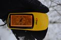
The gps proof.

Achievements
Tilley earned the Bicycle geohash achievement
|
Tilley earned the Frozen Geohash Achievement
|
Tilley earned the Land geohash achievement
|