2014-01-21 52 1
| Tue 21 Jan 2014 in Norwich: 52.3156957, 1.2062963 geohashing.info google osm bing/os kml crox |
Contents
[hide]Location
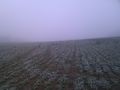
In an oil seed rape field about 75 metres from the road, south of Diss, Norfolk, UK.
Participants
Expedition
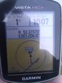
- Arrived. -- Sourcerer (talk) @52.3157,1.2064 10:05, 21 January 2014 (GMT)
The hashpoint was not too far from home and it looked possible to make a triangular trip taking in the hashpoint, a visit to the cemetery where my brother was recently buried and then on to work.
The weather was foggy with a temperature of -1C. There was a convenient place to park at the field entrance. There was a bridge across the little stream and the hashpoint was close to the field edge. The exact position could be reached by following tractor tracks where no seedlings were growing. The land was very wet with an ice crust. The sun was not quite managing to break through.
At the cemetery, everything was OK and I reached work with a couple of minutes to spare. A well planned expedition.
Photos
Proof
The Hashpoint


Achievements
Sourcerer earned the Frozen Geohash Achievement
|
Expeditions and Plans
| 2014-01-21 | ||
|---|---|---|
| Canberra, Australia | 1PE | In a field to the east of Canberra Airport, beside the former drag racing t... |
| Grand Rapids, Michigan | Mcbaneg | North (westbound) side of Richmond St. by Holy Cross Cemetery, Grand Rapids... |
| Pforzheim, Germany | rkschlotte | In a forest near Oberwolfach. |
| Norwich, United Kingdom | Sourcerer | In an oil seed rape field about 75 metres from the road, south of Diss, Nor... |
| Warszawa East, Poland | Ziemek, Ziemba, Norill | Middle of the field in Turów (near Wołomin) |
Sourcerer's Expedition Links
2014-01-20 52 1 - 2014-01-21 52 1 - 2014-02-07 52 1 - KML file download of Sourcerer's expeditions for use with Google Earth.