2014-02-03 49 8
| Mon 3 Feb 2014 in 49,8: 49.3556819, 8.7646178 geohashing.info google osm bing/os kml crox |
no previous next
Location
In the Angelochergraben west of Bammental.
Participants
Plans
I'll use my first hash to find out how the bull I'm riding will handle his first mountains. It's rather far away for an after work trip, but my lack of patience let me try anyway. I'll be there around five in the afternoon. (DODO)
Expedition
So I finished work pretty early and saddled my well-feeded bull to reach my first hashpoint ever. It started easygoing across the plain Oberrheinebene. But at Leimen I reached the Kraichgau and had to start climbing. My mount proofed its qualities and it would have been still comfortable if there wouldn't have been so much traffic. But only to soon I wished myself back on the busy street, when I found myself right in the middle of nowhere on a muddy path. Here my compagnion refused to carry me any further, and so I not only had to walk (or wade) but also must push the heavy cattle through the deep mud. That's so much fun. Then the ground solidifies and a well equipped forrest path brings me up to 100m to the hashpoint, down in a deep creek valley at my left. A short walk through light scrub brings me immediatly in front of a nearly vertical slope but for heavens sake the hashpoint lies on my side of it (at least the gps-advice says so around 90 % of the time with an accuracy around 6 m in the forrest). I left a stone egg, took some pictures (my hashscot didn't feel well, so his best friend has to take part), eat some food and hurried back home.
Tracklog
Photos
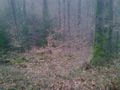
Down there
Lucky, I need not to go further. View from the hashpoint.

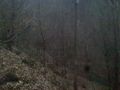
Stupid grin (and I need a better camera for hashing)
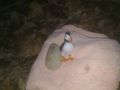
Pago and an xkcdodo-egg (and a towel)

Food (insufficient)


Achievements
Just Land, as long as a bull doesn't count as a beast of burden and not even as a bicycle (my legs tell a different story).
Anyway, the first hash and already an achievement.
DODO earned the Land geohash achievement
|