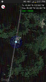
2014-02-22 45 -122
| Sat 22 Feb 2014 in 45,-122: 45.4407217, -122.6612357 geohashing.info google osm bing/os kml crox |
A Saturday Meetup hash on February 20th, 2014 in the Portland, Oregon Graticule.
Location
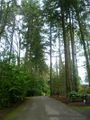
In Lake Oswego on Summerville Ave next to the driveway of a huge mansion.
Participants
Plans
zhukant and TachiTaylor will attempt this one. The plan is to leave the car parked on Military Road, which looks much wider and less suspicious, and walk up the not-a-thru-street Summerville Ave to the hash point. Not sure how long the situation will permit people to stay considering it looks like an ultra-rich gated community.
We are having lunch at the Templeton student center trail room, before heading over to reach the hash at the 2 PM Meetup time.
- - -
The 5000s proceeded in their traditional ignorance of plans.
Expedition
Expedition #5000
Michael and Mrs. drove to the site between 10 and 10:30. We got out of the car, took a few pictures, and then went our separate ways, Mrs. proceeding on a shopping mission and Michael running home, 9.25 miles via the Sellwood Bridge.
Expedition #2
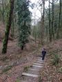
TachiTaylor and zhukant hit up Rite Aid, Fred Meyer, City Target, the food carts and a Shell gas station all along the way to today's Saturday meetup. We got there around 1 PM and scouted the area to see if we would be able to attend the hash okay. After being satisfied, we made our way to the nearby Lewis and Clark college and had our food cart lunch in the common area. What a beautiful campus! We watched a crow try to wrestle some butcher paper out of a trash can for a while, and then went back to the hash at 2 PM, which is what the scheduled meetup time for the graticule is. We chalked xkcd.com on the ground, took some pictures with Scout, and then went for a little hike at the George Hines City Park. Fun hash!
Expedition #3
Jim got stuck in traffic repeatedly, and finally made it to the hashpoint, but everyone else had left. I took a photo of the "xkcd.com" marker, and then headed to the car, where I spent a long time examining the map to figure out my next route.
Expedition #4
Benture was planning a trip south to a birthday party, and I noticed that this was a very do-able hashpoint, even though it looked like it was in a very hoity-toity neighborhood (Google Maps Satellite view showed all the surrounding houses as having outdoor swimming pools). On the way to the hashpoint, we spotted Michael5000 running back home from the hashpoint--we probably missed him by 15 minutes or so.
I was unable to convince the surly teen-aged daughter to get out of the car, and because I felt a little out of place in the neighborhood, I left the dog as well. I spent a good amount of time trying to figure out how to take a screen shot on my phone (of the Geohash Droid app showing I was at the hashpoint), and then I left.
Tracklog
Photos
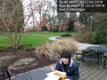
Eating lunch at Lewis and Clark before heading to the hashpoint. @45.4496,-122.6710
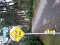
This is where we left our car.
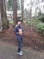
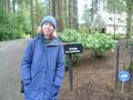
Jack at the hashpoint with Scout our Hashscot.

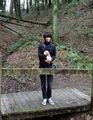
zhukant at the hashpoint with Scout.
zhukant at George Hines Park nearby
TachiTaylor at George Hines Park
zhukant & TachiTaylor's version of proof.

The 5000s celebrate a win.
Mrs.5000
View from the hashpoint.

Benture's goofy grin.


Achievements
- Land Geohash - Everyone