2014-02-26 49 10
| Wed 26 Feb 2014 in Bamberg: 49.7899636, 10.0498246 geohashing.info google osm bing/os kml crox |
Location
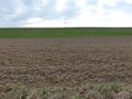
Today's location is in a field near Rottendorf, about 15 m off the field track.
Country: Germany; state: Bayern (Bavaria, EU:DE:BY); administrative region: Unterfranken; district: Würzburg rural district
Weather: partly clouded, around 11°C
Expedition
Danatar
I'm currently taking 3 weeks off work to use up the residual leave from 2013. A hashpoint in cycling distance on a sunny day is the perfect thing to do in that situation. And from my rich history of expeditions to Dettelbach, I knew the route by heart. There isn't much to tell about the trip, except that the sunshine was just warm enough to balance the cold. The spot was reached easily, because it was in a field without any plants, just chunks of soil. Then I realized that I had left Scott at home, right at the end of his hibernation period :-( I took some pictures and went home.
I cycled 2*8.5 km on this expedition. The hashpoint is about 15 m from the field track, and this is the track that I usually use for hashpoints in the Dettelbach area, so there are multiple tracklogs (W-w-where are they? Oh, here's one). thepiguy and srs0 have been on the same field track and srs0's 'special place' is just 300 m away from the hashpoint. So this is almost a déjà-vu location.
almost there
GPS

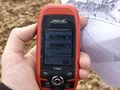
coordinates reached
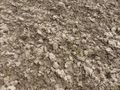
the hashpoint, very interesting
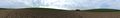
panorama


49 9 location
I also went to my parents on the same day. The plan was to visit the 49 9 hashpoint on my way and I left the Autobahn and drove along country roads through the Odenwald low mountain range. But the sun was replaced by rain and I didn't feel like walking through a wet forest in light shoes, so I aborted the expedition and went to my parents instead. Nonetheless, as nice as they may be in sunshine, in bad weather those winding country roads really suck.