2014-04-19 45 -122
| Sat 19 Apr 2014 in 45,-122: 45.6125737, -122.7139176 geohashing.info google osm bing/os kml crox |
Location
The Smith and Bybee Lakes natural area in North Portland.
Participants
Plans
Jim: Go by after the Farmer's market
Michael5000: Right on a pedestrian pathway through the park, this was such an obviously cool and easy hashpoint that I made a point of getting back to Portland from a trip out of town in time to claim it.
Expedition
Michael5000: Well, it's been raining a lot lately. The lake is quite swollen, and the pathway slipped underwater about 70 feet (20+ meters) from the hashpoint, by my GPS. My kingdom for a boat? Well, a good pair of rubber boots would have done the trick too, but I didn't have any.
Jim: I think I arrived about 15 minutes after M5K and discovered the same sogginess he had. The path to the canoe launch ended in a lot of water about 64 feet before the hashpoint. I took a photo of the water, but was unable to get a photo of my GPS to come out.
However, I don't think rubber boots were going to do the trick. Maybe hip waders. In any event, I was also thinking that "My kingdom for a boat" applied here.
Photos
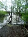
It's just down this path...

Achievements
Michael5000 and Jim earned the My kingdom for a boat consolation prize
|
- There might be alligators? (But probably aren't)