2014-05-01 66 25
From Geohashing

| Thu 1 May 2014 in 66,25: 66.5439160, 25.5564726 geohashing.info google osm bing/os kml crox |
Contents
[hide]Location
In Vennivaara, in a forest.
Participants
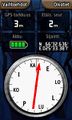
Expedition
- Driving total 24 km
- Walking total 0.3 km
- Expedition took 1 h
- Physical effort (1-5): 1
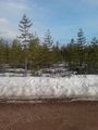
Expedition started about at 6:30 p.m. The hashpoint situated near the forest road, I had to walk only about 150 meters. We have still snow as you can see.
Photos
The Proof.
There it is, 150 m away.
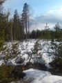
On the way to the hash.
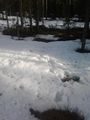
The Hash.
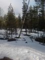
A view from the hash.


Achievements
isopekka earned the Land geohash achievement
|
Geohashing Expeditions and Plans on This Day
Expeditions and Plans
| 2014-05-01 | ||
|---|---|---|
| Christchurch, New Zealand | Quaternary | Sockburn, Christchurch, New Zealand |
| Oahu East, Hawaii | Thomcat | Near Honolulu Airport, just south of the western tip of Mokuoeo Island |
| Portland, Oregon | Jim | Ag land near Newberg |
| Innsbruck, Austria | QuarterCacher, M | Somewhere |
| Frankfurt am Main, Germany | Rincewind | Somewhere |
| Halle (Saale), Germany | TFTD | The Hash seems to be right next to a shed on private property. So might be ... |
| Cottbus, Germany | AmicaNoctis | near Halbendorfer See, Schleife (near Weißwasser), Saxony, Germany |
| Kassel, Germany | GeorgDerReisende | The hash lies beside a road in the forest Reinhardswald. |
| Moscow, Russia | vb | Butovo district. |
| Rovaniemi, Finland | isopekka | In Vennivaara, in a forest. |