2014-05-31 49 8
| Sat 31 May 2014 in 49,8: 49.9179713, 8.3020586 geohashing.info google osm bing/os kml crox |
Location
On a field near Bodenheim.
Participants
Plans
As I have nothing better to do tomorrow, I'll try to go there by bike if the weather is good enough. I want to start at 9 am, so I hope to be there a bit early for a regular meetup, around 2 in the afternoon. I hope to find some wine to drink near the hash before I take the train back to Speyer. -- DODO (talk)
Expedition
I had a long, exhausting and very fine journey, although I didn't get any wine in the end. But lets start at the beginning. Weather today was sunny but not to warm, a moderate breeze blows from the north and the sky was blue. As I had nothing better to do, a perfect day for a ride on the bike, even if todays hashpoint is quite far away (48,8 would have been much nearer but I've been around there before). I left home at a quarter past nine in the morning. I had my first pause in a hut near Ludwigshafen. In Germany, Ludwigshafen has a very bad reputation as it is a town that's based on chemicals industry. But even here you find some deep nature.
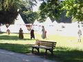
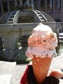
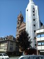
A short time later I reached the river rhine. I came along the Frankenthaler rowing club with a very small house and a short time later I reached Worms. On my way into town I see many people with very strange clothes and after a while I came to a place that was filled with white tents. They had a medieval spectaculum in Worms today. Well, what funny hobbies people do have. Walking around in brand new old fashioned robes, living in tents for a weekend eating meet and drinking met, when they could go on a nearly 100 KM ride on their bike to find some erratic point in the middle of nowhere. In the city center there was some market, but all I bought was some ice cream and ate it at a fountain in the shadow of the cathedral. The cathedral looked funny today, as one of the towers was wrapped. Christo must have been here!
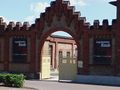
After that I made my way out of Worms and soon reached Osthofen, where I stumbled across something unexpected - at least for me: the KZ Gedenkstätte Osthofen (memorial for the concentration camp Osthofen). Of course I couldn't miss this one and so I went into it and got caught by the exhibition for one and a half hour. It is a deeply impressing contrast to remember all this suffering, the cruelity and death after some hours out, enjoying the beauty of the world, the freedom, the smell of spring in the air, the birds still singing their lovesongs, and the sun, that shines even through the small windows of the building (by the way, the KZ Osthofen lasted little more than one year from 1933 to 1934 and no one died here but that doesn't lessen the depression).
The next adventure waited just when I tried to continue my tour. I switched my tablet of during the visit of the exhibition, and when I wanted to restart my komoot app, it requires some connection to the internet to check my license. But of course there was no free WLAN. I remembered, that I had to go to Nierstein, and hoped, to find some WLAN over there. But some hundred meters later I got an idea: couldn't I use bluetooth to connect the tablet to my mobile and use the internet of the mobile to check the license? And indeed after some trials in guessing the bluetooh-pin (I hadn't used that for years) I could continue my tour well guided. So I reached Nierstein short time later and there I had to left the rhine valley and climb through the "Roter Hang", a world famous vine yard. A steep incline after already eighty kilometers can hurt a lot but I was rewarded by a great view over the rhine.
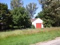
I had to hurry a little now, because I knew that at 16:04 was the only train that goes to Speyer in little more than an hour (every other connection needs nearly two hours). And three o'clock was already gone. But the hash was close now, and soon I reached the field with the barn next to it that I've seen on google maps. The field was dense filled with wheat and I wondered wheter I could go 50 m into it, but then I found some tracktor tracks again and dared to dive in. Of course I didn't get the right one in my first attempt, 12 m of, but I already know the game: Go back outside, walk 12 m along and - indeed, there was another track that leads into the field. OK; I didn't get the zero, but I'm absolutly fine with the 3 m I reached.
So I left the hashpoint and ten minutes later I reached the station in Bodenheim at a quarter to four. Unfortunately to late to try and buy some local wine, but at least early enough to have a beer before jumping on the train.
Tracklog
Photos
hut
nature near Ludwigshafen
rowing club Frankenthal
people in strange clothes ...
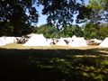
... living in strange tents
provisions
Christo was here
entrance to...
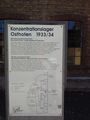
...the camp concentration
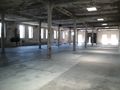
where the people had to sleep - without beds
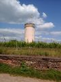
a tower welcoked me at the top of the "roter Hang"
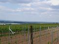
you can see Mainz in the background already
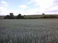
the hashfield
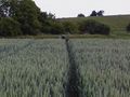
my bike at the end of the first tracktor track
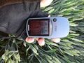
proof
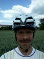
obligatory
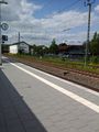
back in civilisation (the train station Bodenheim)


Achievements
DODO earned the Land geohash achievement
|
DODO earned the Bicycle geohash achievement
|
This user earned the xkcd Nullaturion achievement
|
OK,I was a little bit early (15:30), but as no one else was there I claim the ribbon for me.