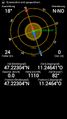
2014-06-09 47 11

| Mon 9 Jun 2014 in 47,11: 47.2230417, 11.2464164 geohashing.info google osm bing/os kml crox |
Location
At a forest road near Grinzens.
Participants
LeslieHapablap (previous|next)
Plans
Go there by bike.
Expedition
This geohash wasn't particularly hard, but today's heat (33°C, 91°F) made it challenging. I was familiar with most parts of the route from previous cycling tours, and therefore I knew in advance that I couldn't expect much shade. And indeed it needed much will power to continue on steadily rising roads while the sun was burning without mercy. Unfortunately Waltraud the hashkiwi had to stay at home today, I didn't want to carry her in the pocket of my jersey because of the warm temperatures.
Finally I made the 500m altitude difference to the village Grinzens and arrived at the point where the paved road turned into a forest road. From there I had to push my bike because it is not suited for these kind of roads, but luckily it was only half a kilometer more to go.
I had to make a few steps into the forest to find the hash point and my GPS reception was quite poor once more. But I managed to get the 0m distance screenshot, albeit with a large uncertainty.
Happy about having reached one more hash point I returned to Innsbruck with a little detour going past Natters and one of our previous geohashes.
Tracklog
Photos
Obligatory proof.
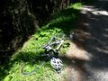
My bike near the hash point.

Exhausted geohasher.
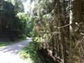
The forest road leading to the hash point.
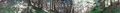
Panorama shot of the hash point.


Achievements
LeslieHapablap earned the Land geohash achievement
|
LeslieHapablap earned the Bicycle geohash achievement
|
LeslieHapablap earned the Consecutive geohash achievement
|