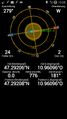
2014-06-22 47 10

| Sun 22 Jun 2014 in 47,10: 47.2920665, 10.9609655 geohashing.info google osm bing/os kml crox |
Location
A forest near Mieming.
Participants
- LeslieHapablap (previous|next)
- Waltraud the hashkiwi
Plans
Stop near the point on our way from Germany to Innsbruck to score an easy hash.
Expedition
- Will go there. -- LeslieHapablap (talk) 14:39, 20 June 2014 (EDT)
The point was only 300 m away from our usual route. Our trip from Germany was alright, but we pitied the poor guys traveling the other direction, it was practically one huge traffic jam all the way from Austria to Germany (holidays ending, everyone traveling back from Austria and Italy). We parked the car on a farm track and EleanorAbernathy waited at the car, because judging from the map the terrain was expected to be quite steep. This is why I went on this expedition only accompanied by our hashkiwi Waltraud. Indeed I had to make my way about 100 meters through thick scrub and very steep descending terrain, apparently full of raptors attacking me from all sides. All of this only to find the hashpoint directly on a perfectly good forest track which was not mapped on openstreetmap yet. While I was taking some pictures, several mountain bikers passed me, so I was not the only one at the hashpoint today.
At least I had a more convenient way back. I recorded the missing track on my device, maybe I will add it to openstreetmaps later.
Photos
Obligatory proof.
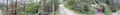
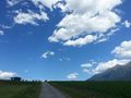
Panorama view of the hashpoint.
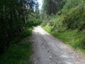
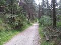
The road I could have taken.
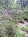
Tho non-road I did take.
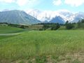
View from the hashpoint, the other direction.
Waltraud at the hashpoint.
Returning to EleanorAbernathy.
One more random picture.

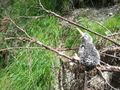
Clearly visible raptor attack marks.


Achievements
LeslieHapablap earned the Land geohash achievement
|
LeslieHapablap earned the Velociraptor Geohash Achievement
|
LeslieHapablap earned the OpenStreetMap achievement
|