2014-07-26 47 11
| Sat 26 Jul 2014 in 47,11: 47.7434847, 11.3978304 geohashing.info google osm bing/os kml crox |
Contents
[hide]Location
The geohash is next to the street between Penzberg and Bichl.
Who Went
TheOneRing - by public transport.
The Expedition
Today's geohash attempt had the potential for a Drowned Rat Geohash achievement, as rain and thunderstorms were forecasted, but not the time.
I went by train to Penzberg via Weilheim and Tutzing, where in Tutzing our train had some problem concerning its engine. Well, I didn't have to change trains thereafter, so I was not in a hurry. Ok, the time until the meet-up ran out, but as I estimated there would still be enough time to reach the geohash.
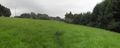
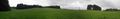
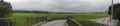
In Penzberg, I walked through the city (as you may call it) towards the geohash. I approached it ten minutes to four, which let time to take the usual photographs. The geohash itself was on a meadow on a hill, but around you could only see forests. So, I walked a little bit backwards to a bridge and took photos for a panoramic view. Unfortunately, the weather conditions were already decreasing and the surrounding was not very impressive.
Around 4pm, no one else came and I walked back to Penzberg to get the following train back home. If the weather had been nicer I would have made a larger tour today, but yeah the summer might last a while.
Oh, before I forget: it did not rain until I arrived back at the train station, no Drowned Rat Geohash achievement for me, consequently.
Photos
The geohash marked by my rucksack
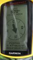
Coordinates reached
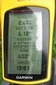
Some more information

The hasher
Panoramic view over the hash, somehow not impressive
Another view, you can see the thick clouds


Achievements
TheOneRing earned the Land geohash achievement
|
TheOneRing earned the Public transport geohash achievement
|
TheOneRing earned the xkcd Nullaturion achievement
|