2014-08-03 48 8
| Sun 3 Aug 2014 in 48,8: 48.9887592, 8.3096274 geohashing.info google osm bing/os kml crox |
Location
In a forest south of Karlsruhe
Participants
Plans
After I checked the northern half of the Stadtkreis Karlsruhe just a week ago, I can hardly resist to check also the southern part (a Regional geohashing achievement within one week!). And as I think I'll have time, I'll try to go there by bike tomorrow. It's a little bit hard to tell when I'll arrive, I think 3 pm is most likely. But if any of the Karlsruher hashers will come, I will do my very best, to be there at any time.
Expedition
I doubted, wether the hashpoint was accessible at all, with the high water in the rhine and the hashpoint situated in the lowland forest. On my way back home yesterday a student told me, that the trains from Karlsruhe to Speyer are replaced by buses. And as I don't want another 100 KM trip on my bike today (to Karlsruhe and back), I decided, to take the bull.
I had to do some homework first, so I couldn't start before 1 pm. But weather was fine, and so I enjoyed the afternoon. I met some animals on my way. Storks are quite common nowadays, and so I didn't even stop to take a photo, but when I came along some goats I had a little break. Then I continued through some fields and crossed the western parts of the city of Karlsruhe. And suddenly I reached the lowland forest with a remarkable terrace of 6 or 7 m height.
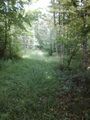
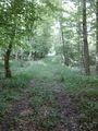
Some 100 m before the hashpoint I reached a sign that announces a preserve area, where it is not allowed to leave the path, but I was lucky, the hashpoint was just outside of its borders. So I continued, but as the forest is very dense, it was nearly impossible to get into it, and from the path I could clearly see a broad ditch, that divides me from my aim.So I ride further and after 200m I crossed the ditch. Maybe... But still no way to get into the forest, and the hash 300m away already. Then I reached a branch to the right and short after that a path to the right again, closed by a wooden barrier and high grass growing on it, but clearly a path. 350 to go. Of course I tried. Not really fun, the grass grow up to my hips and millions of mosquitos were buzzing around me. But the path lead directly to the hash, and I fought my way through it.
When I had 30 m to go, I saw the path ending at a ditch in front of me. On which side of it will the point be? Well, lucky again, some 5 or 6 m before the ditch the Garmin jumped to the rear direction. The forest was lighter here, so I could do some hashdancing. Then I left a marker and headed all the way back to my bull. While I came there on the right side of the rhine, I decided to ride back on the left side. On my way I had to climb a handicap again (at least, if your "bike" has a weight of around 30 kg). So after 80 KM I had to have a break with some food and some beverages, before I continued my ride back home, where I arrived around 6 o'clock, just 20 minutes before a heavy thunderstorm started.
Tracklog
Photos
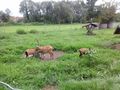
goats on my way
nature reservate. Lucky, the hash is just outside of it.
path to the hash
once again, here the barrier is visible
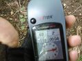
proof

obligatory
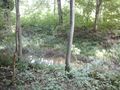
ditch near the hash
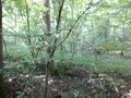
the hashes surrounding
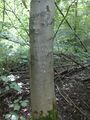
mark
barrier on my way home
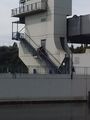
this is the horrifying part of the barrier
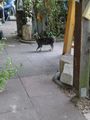
my first hashkitten

food and beverage


Achievements
DODO earned the Land geohash achievement
|
DODO earned the Consecutive geohash achievement
|
DODO earned the Regional geohashing achievement
|