2014-10-26 47 14
| Sun 26 Oct 2014 in 47,14: 47.9757430, 14.1039645 geohashing.info google osm bing/os kml crox |
fyi: This is part one of a two part series describing an attempt to perform the DST Timetravel multihash achievement. For part two please take a look over here.
Contents
Location

The hashpoint was about 10km south of Wels in a rural area next to a barnyard and some storage sheds, in Upper Austria.
Participants
Plans
The Meetup
After their surprisingly successful and, at the same time, unbelievably lucky attempt at performing a daylight saving time time traveler geohash (DST TT) last year (see: 2013-10-27_47_13), Patrizius and B2c jokingly discussed performing another one as it was that time of the year again. Of course they weren't taking it too seriously, because both of them knew: chance was more than slim that the hashpoint distribution would favor them yet another time. On friday evening they met at the Bar Dachboden, enjoying their Gin Tonics at the same time as the beautiful view over the Vienna skyline at nightfall. Little did they know what Lady Luck had up her sleeves for them this year. As they proceeded to check this years' hashpoints they weren't surprised that none of them seemed likely to allow for another DST TT. Only at second sight they slowly became aware that actually, there wasn't one pair of graticules that offered a possible DST TT, but even three! But, all of them came with a twist... It seemed to them that after they had proven their capabilities last year, the hash goddess had stepped up the game a notch this time. But see for yourself the options that were presented to them:
The awesome one
Innsbruck -> Kempten
Maps: http://goo.gl/7QbOVX , 94km, 1h9m
The Innsbruck hashpoint fell only a couple meters short of the shoreline into the Ammersee (Lake Ammer). How awesome would it be to combine a DST TT with a waterhash? But neither of them could come up with any means of water transport as they had no rubber boat, makeshift raft etc. Also it seemed very unlikely that it would be possible to obtain a boat on-site in the middle of the night. But if it would be possible to do so, from then on it was all smooth sailing as the remaining distance was mostly a straight motorway westwards.
The risky one
Maribor -> Zalaegerszeg
Maps: http://goo.gl/7Db1vH , 106km, 1h21m
Both hashpoints where in the vicinity of a motorway which roadway arrangement was well known to them, and they knew that there was lots of headroom on the google maps prediction. B2c knew the first part of the motorway, the so called 'Pack', especially well and felt confident to cut the google maps prediction short a couple of minutes. However, as winter came early in Austria this year and the 'Pack' was more than 1000m (~3300ft) above sea level at the highest point it didn't seem impossible that there would be rain or snow on some part of the motorway.
The rational one
Knittelfeld -> Salzburg
Maps: http://goo.gl/UR9u6k , 116km, 1h10m
The longest route of all three came with a hidden benefit only discovered after a close inspection of the Salzburg hashpoint, which was located in the middle of a park'n'ride car park - no squandering time by running around in cornfields or woods in the middle of the night. But a part of the motorway leading to it was infamous for being foggy and it was more than unlikely that 60 minutes were enough to cover the whole distance. One would have to bend time a little more...
The Hangover
Dumbfounded by those possibilities it seemed clear to them that they at least had to try one of the routes. After making some calls / sending IMs it seemed that this time around there would be three of them trying to perform the DST TT: Patrizius, Micsnare and B2c. Still contemplating their luck they drank up, packed their stuff and soon were on their way home.
It was only on Saturday morning that Patrizius called B2c to inform him that he had some pressing business to attend to at his job and he wouldn't be able to make it. This was pretty much a game changer for B2c as he was famously known for leading himself astray without the help of his trusty wingman he got used to depend on after they had performed a lot of geohashing together recently. He considered calling the whole thing off when Micsnare texted him how excited she was about the whole thing and how much she was looking forward to it. Oh well, onward then! At that point it was pretty much a coin toss between the 'risky' and the 'rational' route. B2c checked the weather forecast again and decided to go with the rational route as the prediction indicated clear skies and dry roads in Salzburg that night.
The Numbers Game
He started comparing last year's route with this one, and didn't quite like what he saw. Last year they had to cover only 90km, most of which were German motorways. This time around the motorway part alone was taking up 90km, and then there where still another 26km of federal roads to go. He knew that he couldn't cover more than 1 kilometer per minute on federal roads, which left him with only 34 minutes for the 90 kilomters of motorway. Or, the other way around: he had to catch up more than 10 minutes on the motorway to make it in time. He was shaking his head silently as he was running the numbers, seeing no way how he was going to accomplish this.
The Location Scout

Being the stubborn ********* he was, he couldn't bring himself to let the thing go and decided to at least take a look at the route connecting the two hashpoints. No harm done by taking a look, eh? On the way to the hashcave he programmed the hashpoints into the GPS app and half an hour later he was already on route to Linz. On the two hour drive he was thinking about possible ways to cut the route short. Sometimes there where maintenance roads which allowed access to the motorway, which in turn could be utilized to get faster from hashpoint to motorway. When he finally arrived at the Knittelfeld hashpoint however, the only maintenance road which allowed access to the motorway was nearly 10km away and it took far to long to get there, so he drove back to the hashpoint, parked the car and took a break. Standing there, overlooking the meadow in which the hashpoint was located he was pondering if it was worth the hassle to continue to the Salzburg hashpoint. Although, the weather was fine and there wasn't much traffic on the motorway, so why not enjoy the road trip a little more? Perhaps some 116 kilometers more to the west?

He took a picture of the hashpoint, set Google Maps to the Salzburg hashpoint on his cell, turned the car around and started the stopwatch. On the motorway he tried to stick to the speed limits as he wanted to get a realistic timing. As not to rush himself too much, he turned off the display of the stopwatch, only turning it on for a short moment sometimes when traffic would allow it and he wanted to record the time on certain waypoints. As he made his way westwards he was surprised to see the ETA on the satnav app melt away minute by minute as he was closing in on Salzburg. As he left the motorway at Eugendorf he gazed at the stopwatch in awe: it showed another 14 minutes to go, exactly the number of kilometers left. Finally on the federal road to the hashpoint he was probably snickering madly, as he put to overtake another tractor causing a little traffic jam in front of him. Was it really possible? He had to force himself to keep his hands off the stopwatch and tried to concentrate on the route. Luckily he avoided missing any turns this time, and when he at last arrived at the car park, braking sharply on the hashpoint he couldn't believe his eyes when he turned on the display of the stopwatch and stopped the timer - in bright letters it read: 00:59:08'82. He texted Micsnare and Patrizius, took a short break and drove back to Vienna. The DST TT was on.
Expedition

Micsnare and B2c met up at 11pm at B2c's flat where he had parked the hashmobile when he came back from Salzburg. B2c had asked Patrizius if he could lend him his brand new GPS (no time mess-up's guaranteed), so before setting off to Salzburg they stopped by his home for a quick chat, gassed up the car, bought some snacks and highly caffeinated beverages and where on their way. As they had lots of time to get to the first hashpoint, they had a nice chat, listened to some music, discussed the route and how they would approach the tasks at hand. Micsnare also had prepared some hash posters (generated by the 'crox' website), so they could mark the hashpoints. When they finally exited the motorway and drove the last couple of kilometers to the first hash point, fog suddenly started to creep up from small creeks located somewhere below them, it started to drizzle and and the temperature dropped to 5°C, all of which didn't bode well.
Eventually they arrived at the hashpoint at around 1:45am, leaving them with some spare time to stretch their limbs, eat some of their snacks and set up for the upcoming run to the next hashpoint. At 1:55am they walked over to the hashpoint, only to notice that the meadow was more similar to a small lake, water momentarily flooding into their shoes. Muttering to themselves they carried on towards the hashpoint. At the hashpoint they couldn't find a place to attach the poster to, so they decided to just stick with it for the time being. At 2:01am they took some pictures, started the timer and quickly ran back to the car. Doors slammed shut, seatbelts clicked, engine revved. The race against the clock had started. Again. Would they make it in time? Only time and maybe this page will tell!
Photos
- Photo Gallery
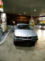
Déjà vu.
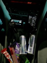
Food for thought.
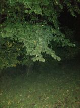
The hashpoint at night.
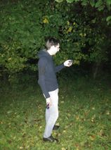
B2c@hashpoint.
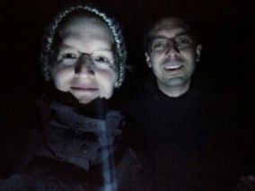
Stupid grin (tm).
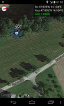
Proof.

More Proof


Achievements
Achievement summary is on part two of the expedition report.