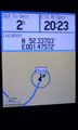
2015-01-26 52 1
| Mon 26 Jan 2015 in Norwich, UK: 52.3370056, 1.4757438 geohashing.info google osm bing/os kml crox |
Location
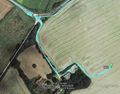
In a ploughed field, south of the Blythe stream and west of Halesworth, Suffolk, UK.
Participants
Expedition
- Arrived. -- Sourcerer (talk) @52.3370,1.4758 20:19, 26 January 2015 (GMT)
The easy-to-reach hashpoints continue. This one was quite close to a public footpath and not too much wading through mud was required. There was a waxing, almost half moon to light the way. There were no significant obstructions on the approach.
There was an off-road lay-by with a litter bin serving a second path parallel with the river Blythe (more of a stream here). This was a good place to park. The service road to a farm crossed the stream and led uphill to the ploughed field. A few metres of mud and there was the hashpoint.
Photos
Track reconstruction
Proof


Achievements
Expeditions and Plans
| 2015-01-26 | ||
|---|---|---|
| Dallas, Texas | Someone went | It appears to be a farm in Heath. |
| Mannheim, Germany | DODO | A meadow near Siegelhain. |
| Norwich, United Kingdom | Sourcerer | In a ploughed field, south of the Blythe stream and west of Halesworth, Suf... |
Sourcerer's Expedition Links
2015-01-25 52 1 - 2015-01-26 52 1 - 2015-01-28 52 1 - KML file download of Sourcerer's expeditions for use with Google Earth.