2015-02-11 52 0
| Wed 11 Feb 2015 in Cambridge, UK: 52.2582551, 0.7769966 geohashing.info google osm bing/os kml crox |
Location
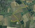
In a field south east of Great Barton, near Bury St. Edmunds Suffolk, UK.
Participants
Plans
This is in a field and it's a good candidate for two hashpoints spanning midnight. The second is 2015-02-12 52 1. To arrive at the second point at midnight, the ETA for this one is 23:10 and departure from base should be 21:40. There will be no moon and dry cloudy weather is likely so it'll be very dark.
Expedition
- Arrived. -- Sourcerer (talk) @52.2582,.7770 22:39, 11 February 2015 (GMT)
I think the GeohashDroid server clock is 6 to 8 minutes slow compared with super-accurate SatNav time. This hashpoint was easier than expected. There was dry parking, off-road. The access to the field was quite dry too. I was expecting it to be seriously dark with no moon but the sugar-beet factory at Bury St. Edmunds was lighting up the low clouds and the terrain could be seen easily without a torch. The field perimeters were easy to walk on and closer to the hashpoint there was a useful tractor track right up to the destination.
Photos
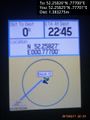
Proof @52.2582,.7770
Track Log


Achievements
Sourcerer earned the OpenStreetMap achievement
|
Expeditions and Plans
| 2015-02-11 | ||
|---|---|---|
| Seattle, Washington | Thomcat | A wooded hillside, south of Chateau Ste Michelle winery and west of the Sam... |
| Kassel, Germany | GeorgDerReisende | The hash lay on a piece of mud in Großalmerode. |
| Cambridge, United Kingdom | Sourcerer | In a field south east of Great Barton, near Bury St. Edmunds Suffolk, UK. |
| Amsterdam, Netherlands | JwB | A parking lot in Aalsmeer |
Sourcerer's Expedition Links
2015-02-10 52 1 - 2015-02-11 52 0 - 2015-02-12 52 1 - KML file download of Sourcerer's expeditions for use with Google Earth.