2015-03-15 42 -78
| Sun 15 Mar 2015 in 42,-78: 42.0847603, -78.4831429 geohashing.info google osm bing/os kml crox |
Contents
[hide]Location
St. Bonaventure cemetery behind the office
Participants
- Pedalpusher (talk)
- Simon the dog
- Myka the dog
Expedition
The plan was to take the dogs out for a really good run in the afternoon and then visit the hash. Since the time-change, we have a lot more light in the evening so there wasn't a huge rush to go. We were finally ready to head out around 14:45.
Our first stop was to McCarty Hill state forest to do some more exploring and we arrived there at 15:30. I was surprised to see no tracks at all on the snow-mobile trail meaning we were the only ones out there the entire day. The snow was still pretty deep in places so we were content to stick to the road. We walked for just about two hours and probably close to 4 miles. There wasn't very much of interest for pictures as everything looked pretty much the same. However, I did see a porcupine up in a tree eating bark off a beech tree(I believe).
On the way out, we passed a lone Mountain biker going up on super-fat tires. I corralled the dogs and said hi as he passed.
Once we got back to the car, we headed for the hash and it took about a half hour to arrive at the cemetery/golf course. I wasn't sure exactly which lot to park in but I ended up in the only obvious lot in front of the golf course clubhouse. Turning on my GPS I saw I was a tenth of a mile away! Uh-oh, did I enter in the wrong coords?
We got out and followed the GPS anyway and ended up in front of the Cemetery office and about 40 feet away. Going down the steps next to the office, we were in a parking lot and right on the mark. I got my pictures and we walked back to the car. It is only after looking at the satellite pictures again that I can see the hash pin covering up the small building that is the office and you can't tell that the parking lot is a lot lower than the road in front. That's why I drove right by it. Anyway, success being had, we headed for home after taking some pictures of the golf course area.
On a personal note, I thought it a strange setup with the golf course right next to the cemetery and a shared entrance.
Photos

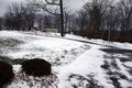
The hike was nice but visually boring...
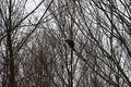
But we did get to see a porcupine!
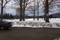
I'll take my chances parking here today. The sign says: "The University is not responsible for damage to vehicles parked in this area". This area is right next to the Tee area for the first hole.
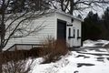
Getting to the hash, we paused in front of the (what appeared to be empty) cemetery office.
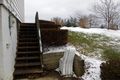
So we went down the steps to the hash.
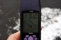
Where we were under 3 feet away from the hash.
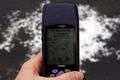
Accuracy of the GPS.

Standard grin.
View toward the car from the hash.
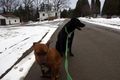
Forgot to take a picture of the dogs at the hash so we got one on the way back to the car.


Ribbons
This user earned the Land geohash achievement
|
Pedalpusher earned the Holy hash achievement
|