2015-06-23 39 -89
| Tue 23 Jun 2015 in 39,-89: 39.9234485, -89.8941566 geohashing.info google osm bing/os kml crox |
Location
On the side of Niemeier Rd, near Tallula, IL
Participants
Plans
Bike there from Springfield, around 10am
Expedition


Another day off work, and another geohash within 20 miles off to the northwest. Many of the roads I would use to reach this one are the same roads I took to the 2015-06-07 and 2015-04-16 geohashes. Seems to me that a bike trail needs to be built out this way if I'm going to be geohashing in the area so often!
I decided to make this one a "light" expedition, as in I would be traveling with the minimum amount of gear. There were two reasons for this. Firstly, it's summer in the midwest, which means temperatures were likely to reach 90 degrees fahrenheit, and carrying a bag on my back would cause me to overheat quicker. Secondly, carrying a bag, or even having one on the bike, would add to the wind resistance and cause me to tire quicker. So it was decided that I would carry only my phone which functioned both as a GPS and camera, my ID, and my hashscot Collin. With the phone mounted to my bike for navigation and the rest of the gear in my pockets, I strapped on my helmet and headed for the door.
Then I suddenly remembered something that could have been disastrous: I hadn't eaten yet! No matter how fit I could possibly be, leaving on a 33 mile bike ride on an empty stomach would be a terrible idea. I was forced to delay my departure until breakfast was eaten, and finally around 10:45am, I left home.
Following the GPS navigation, I was led along route 97 out of Springfield, which wasn't an ideal route for one very big reason. There was absolutely no hard shoulder. I was forced to ride along the white line on the very edge of the road, on a high speed road with little room for passing. On a number of occasions I heard large trucks slowing down behind me and was forced to move onto the gravel to make room for them to pass. As terrifying as it was though, I must give the drivers I encountered credit: they offered me plenty of space while passing me.
Route 97 turned into Route 125, but was no wider. After what seemed like an eternity (partly due to the headwinds I imagine), I arrived at my turn, and was now on mostly deserted country roads. Once again, the GPS led me down a poorly maintained road that was as much gravel as it was pavement, but luckily for myself, the road the hash lay next to was in better shape. Or so I thought.
As I turned onto Neimeier Road, a depressing sight came into view. A large "Road Closed" sign sat in the middle of the road. After more than 16 miles of riding, I was sitting 1,000 feet from the hash and the road was closed. Or was it? I could look ahead and see the other end of the closure, and what looked like a freshly dug up area of the road in between. For cars, there would be no way by without driving through the fields to get around the road work. But I was on a bicycle, and could sneak by without disturbing anything. As I approached, I noticed that the road had been cut up to work on a drainage pipe that ran beneath it. I cautiously walked my bike around, and slowly pedaled the last couple hundred feet to the hash.
As seen on the aerial views, the hash lay on the very edge of a field of corn. Whether or not it actually lay inside the crop didn't matter, as I was able to get inside my margin of error standing in the tall grass on the edge of the field. Another successful geohashing expedition! Unlike my last bike hash I actually had time to take photos. I had a drink of some water, packed my stuff back up, and began the ride home.
The way home was both better, and worse than the way out. I had a tailwind, which my legs very much preferred to the light, but steady headwind I had fought out to the hash. However, that meant that I had almost no wind passing over me to cool my body down. As I rode on, not only was my body temperature going up, but so was the ambient temperature. What had been 80 degrees when I began rose to over 90 by the end of my ride. I exhausted my water supply about halfway back, and just 4 miles from home, body decided that enough was enough and I hit "the wall". I had decided to take a different route home the last few miles to get away from the traffic along Route 125/97 sooner, but it was far hillier, and I had already spent all my energy by the time I arrived at my turn. Somehow, I willed my way up each hill, and despite hyperventilating the whole way, made it home safely. After drinking over a liter of water, and sitting in a cool bath to cool off, I took a much deserved afternoon nap to celebrate.
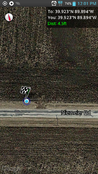
Tracklog
Photos
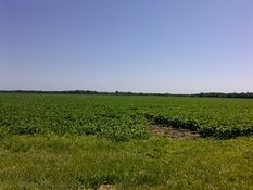
Young soybean field
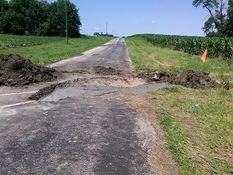
Cars shall not pass (but bicycles are ok)
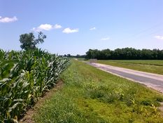
From the hash looking east
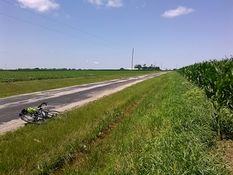
From the hash looking west
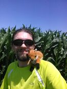
Happy but tired geohashers
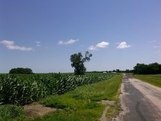
Photogenic view of the hash area
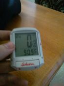
Temperature when I arrived home
Proof!


Achievements
Mystrsyko earned the Land geohash achievement
|
Mystrsyko earned the Bicycle geohash achievement
|