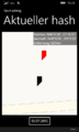
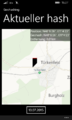
2015-07-13 48 11
| Mon 13 Jul 2015 in 48,11: 48.1072906, 11.0731050 geohashing.info google osm bing/os kml crox |
Contents
[hide]Location
The geohash is next to a street right at the exit of Türkenfeld.
Who Went
- TheOneRing - by car.
The Expedition
TheOneRing
Last weeks were busy, so I couldn't go geohashing at all. Consequently, seeing the opportunity today, I wanted to try. Today was my alphorn lesson, and the geohash was (approximately) on the road, I only had to leave the autobahn two exits earlier. I parked on an parking lot near the train station and walked.
The geohash itself was next to a street, approx. 100m outside of Türkenfeld. The name of the towns means something like "where the Turkish are" and comes from the Ottoman wars in Europe in the 15th century and later.
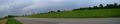
It rained a bit, I didn't spend more time than necessary. After all, alphorn lessons were scheduled. Apart from corn and crop fields there were not much seen anyway. After taking the usual photographs, I walked back and left Türkenfeld.
Photos
TheOneRing
Coordinates reached, at least within accuracy
Same view on a bit larger scale

Umbrella-equipped hasher
Crop fields
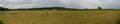
Panoramic view from the hash over Türkenfeld


Achievements
Maybe this geohash would qualify for an Easy Geohash, but I skip that, and it didn't rain enough for a Drowned Rat Geohash.
TheOneRing earned the Land geohash achievement
|