2015-07-17 52 1
From Geohashing
| Fri 17 Jul 2015 in Norwich, UK: 52.5124496, 1.0433368 geohashing.info google osm bing/os kml crox |
Location
In a field east of Attleborough, Norfolk, UK.
Participants
Expedition
This hashpoint was 990 metres from my expedition to 2015-05-03 52 1.
- Arrived. -- Sourcerer (talk) @52.5124,1.0433 22:17, 17 July 2015 (GMT+01:00)
This was easy. There were obvious tractor tracks into the barley field. The second set of tracks got me to the 6 metre mark. I chose not to zero the distance to avoid crop damage.
I was able to confirm the accuracy of the private farm track I had earlier added to OpenStreetMap.
July is proving to be an unlucky month with more than the usual number of hashpoints landing in the sea.
Photos
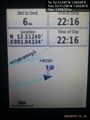
Proof. @52.5124,1.0433
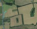
Track in Google Earth


Achievements
Sourcerer earned the OpenStreetMap achievement
|
Expeditions and Plans
| 2015-07-17 | ||
|---|---|---|
| Pforzheim, Germany | RecentlyChanged | Near a small pass in the black forest. |
| Stuttgart, Germany | Ekorren | No trespassing. Walked there and took a look. Report might be done before 2... |
| Nürnberg, Germany | Schnatterfleck | The watering pipeline in a field of celery near Kraftshof. |
| Norwich, United Kingdom | Sourcerer | In a field east of Attleborough, Norfolk, UK. |
| Warszawa East, Poland | Ziemek, Ziemba, Norill | Middle of the field in Serock. |
Sourcerer's Expedition Links
2015-07-14 52 1 - 2015-07-17 52 1 - 2015-07-19 52 1 - KML file download of Sourcerer's expeditions for use with Google Earth.