2015-07-25 52 0
| Sat 25 Jul 2015 in Cambridge, UK: 52.3067980, 0.8888245 geohashing.info google osm bing/os kml crox |
Location
A few metres off a public footpath, east of Wyken Hall, Suffolk, UK.
Participants
Plans
Expedition two of two spanning midnight - 2015-07-24 52 1 - 2015-07-25 52 0 - ETA 00:00
Expedition
Rain was predicted and it poured!
- Arrived. -- Sourcerer (talk) @52.3068,.8889 00:06, 25 July 2015 (GMT+01:00)
There were nice wide mown tracks and a footbridge along the public right of way. There was no moon, low cloud, a gusty breeze and quite a lot of rain. In fact this was bracing. The air was cool and clean, straight off the Atlantic ocean. The hashpoint was on the border between a narrow strip of woodland and a wheat field. There was another hash-circle at the exact location. This ninja hasher must have sneaked in, trampled the weeds and departed in under six minutes. Something else must be making these hash circles but how the hashpoints get selected is a mystery.
Photos
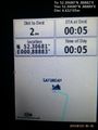
Proof. @52.3068,.8889
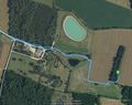
Track in Google Earth.


Achievements
The OSM footpaths were incomplete. I added the missing bits.
Sourcerer earned the OpenStreetMap achievement
|
Sourcerer earned the Midnight Geohash achievement
|
Expeditions and Plans
| 2015-07-25 | ||
|---|---|---|
| Gympie, Australia | Benjamin Kaiser, Eden Vicary | Out in the bush, sort of between Maroochydore and Gympie. |
| Danbury, Connecticut | OtherJack | Overgrown attempt at development, east of Peekskill |
| Midland, Michigan | Mcbaneg | In a wood near Carpenter Creek, Sumner, MI, USA. |
| Portland, Oregon | Jim | Ag land near Tualatin |
| Ottawa, Ontario | Jlam | Bujold Ct in Kanata |
| Cambridge, United Kingdom | Sourcerer | A few metres off a public footpath, east of Wyken Hall, Suffolk, UK. |
| Globalhash | Someone went | GLOBALHASH -- Near a country road, in eastern South Australia's grain-belt.... |
Sourcerer's Expedition Links
2015-07-24 52 1 - 2015-07-25 52 0 - 2015-07-26 51 1 - KML file download of Sourcerer's expeditions for use with Google Earth.