2015-08-19 52 1
| Wed 19 Aug 2015 in Norwich, UK: 52.5924958, 1.4890084 geohashing.info google osm bing/os kml crox |
Location
North of the river Yare and east of Buckenham railway station, Norfolk, UK.
Participants
Plans
Sunday, Monday and Tuesday were in the sea. Thursday is in a private house garden.
This looks difficult. Near the river there is a lot of livestock grazing so access might not be possible.
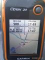
Expedition - Fail
- Fail livestock -- Sourcerer (talk) @52.5881,1.4844 16:42, 19 August 2015 (GMT+01:00)
As expected, this was not accessible. I'm happy to walk along field perimeters and tractor tractor tracks but as soon as livestock and wildlife might be disturbed, I go into "no trespassing" mode.
This was a rather wonderful location. The walk started at a railway crossing close to a "Royal Society for the Protection of Birds" reserve. Then it ran along the banks or the river Yare. The access to the hashpoint was through fields with cows so I chose not to proceed following my "no damage, no disturbance" rules. A potential alternative route had nesting swans so that was ruled out too.
There was almost a pub geohash but the ferry which might have taken me across the river stopped running years ago - sad.
I found and ate ripe blackberries on the route.
I arrived back home, tired, thirsty and hungry so I fed the dog and headed towards the Green Dragon (curry night). They were busy and I had to wait two pints for the food to arrive. Who knew you could measure time in pints! The pub was full of kids, dogs, happy grown-ups, ancient old men and there were no shouty drunks. I ate a fine curry (Red Thai Beef). In the pub, there was a boy, possibly eighteen (to be there legally), dressed as a pirate, brandishing a fake cutlass. Even the American police would realise it was fake and anyway he was white! His dress was possibly in poor taste. He had a yellow tee-shirt, a large backpack, dark glasses and a pirate's hanky on his head, hiding his hair. He was the spitting image of the Bangkok Bomber and completely unaware of what he'd done! This created quite a lot of good humoured banter after Google Images had been consulted as well as some moments of pause, remembering the sadness and stupidity of blowing people up!
I added the windmill and a section of footpath to OpenStreetMap.
Photos
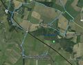
Track in Google Earth
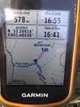
Proof of Fail
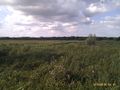
View towards the hashpoint
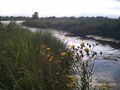
View near the hashpoint
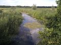
View near the hashpoint
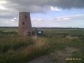
The disused windmill and electric pumping station
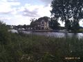
The unreachable pub
More proof of Fail


Achievements
Sourcerer earned the OpenStreetMap achievement
|
Sourcerer earned the No trespassing consolation prize
|
Expeditions and Plans
| 2015-08-19 | ||
|---|---|---|
| Tunis, Tunisia | Dunaril, Katu | Near or on a small canal close to the city of Grombalia, 40km away from Tun... |
| Mannheim, Germany | DODO, tads | On a playground of a daycare in Lampertheim. |
| London East, United Kingdom | Huinesoron | On the verge of the A127, north of Basildon |
| Norwich, United Kingdom | Sourcerer | North of the river Yare and east of Buckenham railway station, Norfolk, UK.... |
| Schwerin, Germany | Aba | Near a small canal close to the city of Schwerin (capital of Mecklenburg-Vo... |
Sourcerer's Expedition Links
2015-08-15 52 1 - 2015-08-19 52 1 - 2015-08-21 51 0 - KML file download of Sourcerer's expeditions for use with Google Earth.