2015-08-22 49 8
| Sat 22 Aug 2015 in 49,8: 49.6552329, 8.7231957 geohashing.info google osm bing/os kml crox |
Location
A small forest near the sports ground in Heppenheim-Mittershausen
Participants
Plans
I want to go there by bull tomorrow afternoon. I hope, I'll arrive at 4 and would be very happy to meet some other hashers.
elimik31: If I feel fit in the morning, I want to use the perfect weather and go by bycicle. According to graphhopper it is 95 km, which would be my personal distance record for geohashing. I assume that I will want to get back by train. However, I have had a very light cold in the beginning of the week. If I don't feel well in the morning, I will probably stay at home. I hope that I will be in time for 4 pm. It will be close.
Expedition
DoDOs expedition
Plans had to be changed a little bit. I have to drive big car to Heidelberg, and so I will start bulling there. That's pretty nice as I can drive through the Odenwald and didn't have to cross the rhine valley (and bull will help me to climb all the mountains). I'll start soon, but I'm not sure if I'll make it till 4. DODO (talk) 07:19, 22 August 2015 (EDT)
And so I did. I put the bull in the car and drove to Heidelberg. I let the car there and started at 14:15. I had 46 KM to go to the hash so I was in a little hurry already, even with the support of my bull. And a lot of obstacles were in my way again. First I had to go through Heidelberg with all its traffic and - all its traffic-lights. It felt like I had to wait on every single one. Then I rode into the Peterstal, and had to climb 300m upwards. On that part there were roadworks and another traffic light with a clock that counted down - from 150 when I arrived. So I had to wait for 2 1/2 minutes to continue. After that the way goes down again. But I missed my way and went way more down than I wanted - and up again of course. A lot of further obstacles followed, a steep gravel road with rough stones where you could hardly go faster than 15 km/h, a tractor on a good downhill road, that couldn't be overtaken, but didn't go faster than 10 km/h and so on.
Nevertheless I came near the hash at 16:08. I was on a path that ended in a field, 20 m from the hashpoint. I let the bull there and walked to a big chestnut tree. From here it was just 7m to go, on a steep slope into the forest. An electric fence was in the way but could easily be crossed. I climbed into the slope, and came to a 2, what was good enough for me today, so I quickly climbed down to the chestnuts again. Down there I left a mark and waited until 16:30. But elimik didn't show up nor did anyone else (hey, Q-Owl, it's almost in your backyard) (meanwhile I know that Elimik had a much harder way than me (at least he was riding a bike and not an electric bull) and didn't make it in time. Sorry, I hope you find the mark).
I've seen at eupeodenes that there is a really nice inn just 500 m from the hash and so I stopped waiting and rode there to celebrate my success. To bad that I couldn't share it with someone else. I always had a look at the road for Elimik but that probably wasn't his route. After a little more than half an hour I continued my way, rode down to Heppenheim and then through a big forest to Mannheim. From here I took the train home and arrives at 19:30. I made some handmade french fries and some mayonnaise and a roasted tuna steak before I wrote this report.
Elimiks expedition
I am on my way, but I will also be ~1 h late.Elimik31 (talk) 08:34, 22 August 2015 (EDT) 1.5 h (17:30), sorryElimik31 (talk) 10:17, 22 August 2015 (EDT) Now prob. 6 pm. 20 km left.
Tracklog
84 KM by bull or 25 KM by car, 84 KM by bull and 24 KM by train
Photos
DODOs photos
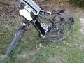
bull near hash
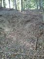
it's half way up there (you can see the electric fence in the lower part of the photo)
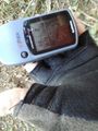
proof

I look exhausted - but happy
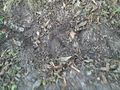
first try for a mark
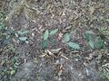
pimped it up with some chestnut leaves
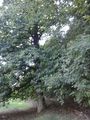
the chestnut tree
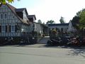
Vetters Hof, a really nice inn
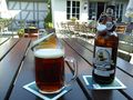
with beer
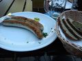
and sausages


Achievements
DODO earned the Land geohash achievement
|
DODO earned the xkcd Nullaturion achievement
|